Thursday, January 31, 2013

The Knowlton Rings SW of Stonehenge as Astronomy: These are Stars of Taurus at the Vernal Equinox Point ca. 3000 BC including at Least One of the Hyades and showing also Stars of the Neighboring Pleiades

The Knowlton Rings are barrows viz. tumuli located in East Dorset, England, United Kingdom, southwest of Stonehenge at a location which would correspond astronomically to the stars of Taurus, given our previous postings, and thus it is not surprising that the Knowlton Rings in fact mark the Vernal Equinox ca. 3000 B.C. via the stars of Taurus and at least one of the Hyades. For orientation, the stars of the Pleiades are also marked to the northeast.

Google Earth is of little use here, but we found an image online by Steve Burrow of Bournemouth which shows a full archaeological survey map of the Knowlton Rings. Since that image is copyrighted, we redrew the entire map to a larger size (it may not be exactly to scale as a result) and added our astronomical explanations.

Two images were required to be able to show the full correspondence of the barrows and tumuli on Earth with the stars in the heavens.

The Pleiades are so clear as be without any possible astronomical dispute. Indeed, even the famed seven-star symbol of the Pleiades is apparently used. However, the Pleiades doe not represent this megalithic site, but have only been added here for completion of the location by the ancients.

Knowlton itself is defined by the stars of Taurus near Aldebaran and the Hyades. In Taurus, stars important to marking the Vernal Equinox point on the ecliptic are given priority so that the major star Aldebaran is only marked to the right of the larger rings without any greater significance, as it is not on the ecliptic. The same holds true for the Hyades. However, numerous stars can be identified with little difficulty, as shown in the following images.

Image 1 of 2 of the Decipherment of the Knowlton Rings


 Image 2 of 2 of the Decipherment of the Knowlton Rings


Obviously, the interpretation of one megalithic site alone does not prove the hypothesis that ancient barrows and tumuli, viz. tumps, marked stars in the sky as part of archaic astronomical practice and also as hermetic land survey -- as above, so below -- but when one can start to incorporate several megalithic sites, as we have done in past postings, into a cohesive interlocked system, then the likelihood that the hypothesis is correct has been magnified algebraically.


Monday, January 28, 2013

Cetus at Stonehenge: If Tumps, Tumuli and Barrows in Ancient Britain Represented Stars, the Tumuli Below Stonehenge are the Stars of Cetus


Cetus at Stonehenge: If Tumps, Tumuli and Barrows in Ancient Britain Represented Stars, the Tumuli Below Stonehenge are the Stars of Cetus

Take a look at Google Earth and the tumps (also called tumuli viz. barrows) that surround Stonehenge, including the cursus and "cursus barrows" (labeled as "curcus barrows" by some Panoramia gallery users at Google Earth).

The bottom half of the image below shows tumuli to the South of Stonehenge that can be viewed at Google Earth.


A clipped Google Earth map of the area below Stonehenge is reproduced at the bottom of the image above. Compare that map with the star image directly above it by Robert Mura, CC-BY-SA 3.0, from Software Perseus, via Wikimedia Commons http://commons.wikimedia.org/wiki/File:Cet.png.
 
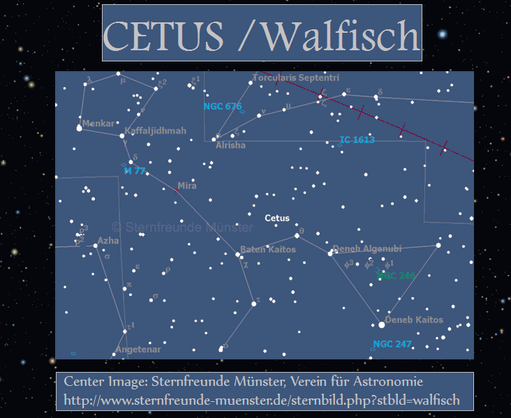
Compare now the following star map which has the same relative size as the star map above, and that is why we use it, but is here imposed upon it, showing names of stars and the modern view of Cetus. We see that the ancients used many of the same stars, but at that time had a different resulting conception of what Cetus represented.


The image directly above from http://www.sternfreunde-muenster.de/sternbild.php?stbld=walfisch is copyrighted at the website of Sternfreunde Münster, Verein für Astronomie, which has a terrific astronomy website at http://www.sternfreunde-muenster.de. We post it here as fair use. Do not be put off by the fact that it is in German language, as astronomy is by and large international in scope, so that the images of constellations can be understood by anyone, as above.

In any case, as previously stated, if the tumps, tumuli and barrows of Ancient Britain marked stars in the heavens, as we argue they did (see megaliths.net), then these tumuli clearly mark the stars of Cetus and I have added red lines to show the stars corresponding to the appropriate tumuli.

There is a line of tumuli below these and those are also stars of Cetus and further down the line stars of Eridanus and Fornax, as identified on our main decipherment image some postings previous to this one. There are several obvious "lines" of stars extending down from Cetus and Eridanus but we superimposed images of the stars from Starry Night Pro on variously sized maps of Google Earth and they showed that the line we identify is the line intended by the ancients.


The Pleiades at Stonehenge: If Tumps, Tumuli and Barrows in Ancient Britain Represented Stars, the Tumuli to the Left of Stonehenge are the Pleiades


Take a look at Google Earth and the barrows (also called tumuli viz. tumps, i.e. "earth mounds") that surround Stonehenge.

The image below shows tumuli to the left of Stonehenge that can be viewed at Google Earth, as these tumps are found just above and to the right of the roundabout (intersection) on the road to Winterbourne Stoke.


A clipped Google Earth map of the area around Stonehenge is reproduced at the top of the image above. Compare that map with the star image directly below it based on Starry Night Pro (http://astronomy.starrynight.com/) star positions, and compare both maps with the bottom photo found at Vladislav Yastrebov of the Pleiades and nearby stars at http://yastrebov.fr/photo_astro.html (c) Vladislav Yastrebov (posted here as "fair use").

If the tumps, tumuli and barrows of Ancient Britain marked stars in the heavens, as we argue they did (see megaliths.net), then these tumuli clearly mark the Pleiades.

But that is not all, as the other groups of tumuli directly surrounding Stonehenge then represent, as they must, the stars of Aries and the stars of Cetus, i.e. nearby stars to the Pleiades, as we show in the following postings.


Stonehenge Earthworks Decipherment: Image Map of Results (12 Color Resolution)

Repeat of the previous posting but showing a lowest resolution map of only 12 colors, which may have some advantages....

This posting shows the overview map of materials explained in greater detail in subsequent postings, showing that the barrows, viz. tumuli or tumps (in America, "mounds") that are nearest to Stonehenge served as astronomical markers, principally marking stars in a system of astronomical measure and attendant land survey that extended far beyond Stonehenge.

See also megaliths.net.

The system of barrows seems to have its origin at least as far back as 3000 B.C.  According to our analysis, the long barrow at Winterbourne Stoke Crossroads marks the crossing point of the ecliptic, ecliptic meridian and celestial meridian at the point of the Vernal Equinox ca. 3117 B.C. That conclusion supports e.g. Professor Julian Thomas of Manchester who assigns an ancient date beyond 3000 B.C. to some of these earthworks.

OVERVIEW MAP of Stonehenge and the Nearest Earthworks
lowest resolution image (only 12 colors) as a .png file
you may have to scroll the image


This posting is now followed by an analysis of the various groups of barrows, viz. tumuli or tumps, in subsequent postings.
__________

Of interest in this matter
in terms of formal archaeological examination
of the Winterbourne Stoke Barrows
is the English Heritage report
by S. Newsome, M. Bowden, A. Komar, and S. Bax
in Report Number 107 of the year 2010 titled
Stonehenge World Heritage Site Landscape Project: Winterbourne Stoke Crossroads, Report Number: 107/2010, Series: Research Department Reports
Pages: 56, English Heritage.

See http://research.english-heritage.org.uk/report/?14949


Stonehenge Earthworks Decipherment: Image Map of Results (16 Color Resolution)

Repeat of the previous posting but showing a lower resolution map of only 16 colors, which has some advantages....

This posting shows the overview map of materials explained in greater detail in subsequent postings, showing that the barrows, viz. tumuli or tumps (in America, "mounds") that are nearest to Stonehenge served as astronomical markers, principally marking stars in a system of astronomical measure and attendant land survey that extended far beyond Stonehenge.

See also megaliths.net.

The system of barrows seems to have its origin at least as far back as 3000 B.C.  According to our analysis, the long barrow at Winterbourne Stoke Crossroads marks the crossing point of the ecliptic, ecliptic meridian and celestial meridian at the point of the Vernal Equinox ca. 3117 B.C. That conclusion supports e.g. Professor Julian Thomas of Manchester who assigns an ancient date beyond 3000 B.C. to some of these earthworks.

OVERVIEW MAP of Stonehenge and the Nearest Earthworks
lower resolution image (only 16 colors) as a .png file
you may have to scroll the image


One lower resolution posting of only 12 colors follows, followed by analysis of the various groups of barrows, viz. tumuli or tumps, in subsequent postings.
__________

Of interest in this matter
in terms of formal archaeological examination
of the Winterbourne Stoke Barrows
is the English Heritage report
by S. Newsome, M. Bowden, A. Komar, and S. Bax
in Report Number 107 of the year 2010 titled
Stonehenge World Heritage Site Landscape Project: Winterbourne Stoke Crossroads, Report Number: 107/2010, Series: Research Department Reports
Pages: 56, English Heritage.

See http://research.english-heritage.org.uk/report/?14949


Stonehenge Earthworks Decipherment: Image Map of Results (High Resolution)

This posting shows the overview map of materials explained in greater detail in subsequent postings, showing that the barrows, viz. tumuli or tumps (in America, "mounds") that are nearest to Stonehenge served as astronomical markers, principally marking stars in a system of astronomical measure and attendant land survey that extended far beyond Stonehenge.

See also megaliths.net.

The system of barrows seems to have its origin at least as far back as 3000 B.C.  According to our analysis, the long barrow at Winterbourne Stoke Crossroads marks the crossing point of the ecliptic, ecliptic meridian and celestial meridian at the point of the Vernal Equinox ca. 3117 B.C. That conclusion supports e.g. Professor Julian Thomas of Manchester who assigns an ancient date beyond 3000 B.C. to some of these earthworks.

OVERVIEW MAP of Stonehenge and the Nearest Earthworks
highest resolution image as a .png file
you may have to scroll the image

Stonehenge Earthworks Deciphered High Resolution Image
Stonehenge Earthworks Deciphered (high resolution image)
Two lower resolution postings follow, and those are followed by analysis of the various groups of barrows, viz. tumuli or tumps, in subsequent postings.
__________

Of interest in this matter
in terms of formal archaeological examination
of the Winterbourne Stoke Barrows
is the English Heritage report
by S. Newsome, M. Bowden, A. Komar, and S. Bax
in Report Number 107 of the year 2010 titled
Stonehenge World Heritage Site Landscape Project: Winterbourne Stoke Crossroads, Report Number: 107/2010, Series: Research Department Reports
Pages: 56, English Heritage.

See http://research.english-heritage.org.uk/report/?14949


Stonehenge Earthworks: Google Earth plus Astronomy: The Introduction


This series of postings presents our alleged (and surely imperfect)
pioneer astronomical decipherment of the ancient man-made earthworks nearest to Stonehenge. Our main tools are Google Earth and Starry Night Pro, so that our reasoning can easily be followed by professional and layman alike.

In Britain, earthworks are called barrows, tumuli, tumps, dykes, cursus etc., while in America comparable earthworks are generally referred to as mounds.

Have we identified everything correctly at Stonehenge and environs?

That would be unlikely, after thousands of years, but we think we have made progress over previous research and analysis. We hope that others will be able to build on our results. As a matter of fact, we have had no one to check our work up to now, so that inspection can start now. Have fun.

We suggest that the ancient earthworks nearest to Stonehenge are "hermetic" marks of "archaic" astronomy. See megaliths.net for the principles involved and also our recent posting about the monuments of Kilmartin.

We have identified specific groups of tumuli near Stonehenge as marking stars of inter alia Perseus, the Pleiades, and Cetus. We think these are so clear as to be without serious doubt to anyone who follows up the analysis. Identifying e.g. the stars of Aries, on the other hand, is a judgment call.

Our interpretation of the complete astronomy will surely need much further work, especially in terms of the actual chronology and more complex matters of precession, the position of the ecliptic and celestial and ecliptic meridians. 

Stonehenge is apparently located on the ecliptic in this system, but it could only have marked the Vernal Equinox ca. one full Sothic-like cycle (ca. 1460 years) AFTER it was actually last constructed, as we know the structure today, so this location can only be found in an era prior to the earthwork system.

Hence, the current location of Stonehenge can only be as a direct successor to previous (we assume wooden) structures erected for the Winter Solstice, ca. 7500 B.C. by our reckoning, a Winter Solstice point which was located where Stonehenge today stands in an era that marked the end of the last ice age.

In fact, those are the oldest astronomical remnants at Stonehenge, post holes dating to ca. 10000 years before the present, as written at megalithia.com (© Richard M 1992-2008):
"The people of the Mesolithic period who erected the pine posts near Stonehenge are unlikely to have known of the grand vision which was to come. Nevertheless, they erected three huge pine posts in the great pine forest that covered the site at the time. The 1960's car park is built over these - the large round discs you can see in the car park are the modern markers for these 10,000 year old holes..."
This "archaic" astronomy was surely a product of mankind's attempt to discern the natural laws of the Sky above and the Earth below on which men and women found themselves in the ancient era. They were not unlike us in looking to explain their world.

Take a look at The Life of the Law and the posting

and consider the following quotation
that we found in a book
we recently downloaded
to our Android smartphone via Google Play,
as modernity meets antiquity:

That downloaded book is by Harold Bayley, Archaic England: An Essay in Deciphering Prehistory from Megalithic Monuments, Earthworks, Customs, Coins, Place-Names, and Faerie Superstitions, Chapman & Hall Ltd., London, 800 pp., published 1919.


Bayley quotes A. Hadrian Allcroft on earthworks as follows:
"Of all the many thousands of earthworks of various kinds to be found in England, those about which anything is known are very few, those of which there remains nothing more to be known scarcely exist.

Each individual example is in itself a new problem in history, chronology, ethnology, and anthropology; within every one lie the hidden possibilities of a revolution in knowledge.

We are proud of a history of nearly twenty centuries: we have the materials for a history which goes back beyond that time to centuries as yet undated.

The testimony of records carries the tale back to a certain point: beyond that point is only the testimony of archaeology, and of all the manifold branches of archaeology none is so practicable, so promising, yet so little explored, as that which is concerned with earthworks.

Within them lie hidden all the secrets of time before history begins, and by their means only can that history be put into writing: they are the back numbers of the island's story, as yet unread, much less indexed.
"
- A. Hadrian Allcroft [Earthwork of England: Prehistoric, Roman, Saxon, Danish, Norman and mediæval, Macmillan Co., Ltd., London, 1908, p. 20].
The next 3 postings will each present one large image of the concluding results of our Stonehenge earthworks research and analysis, each in a different resolution in order to accommodate the differing monitors and PC technologies that the user may have at her or his disposal.

First, we show the image in high resolution as a large .png file. 237 KB. That may present a download problem for some.

Second, we show the image in only 16 colors as a .png file. 98 KB.

Third, we show the image in only 12 colors as a .png file. 80 KB.

The reduced colors may actually make it easier to see the results, since the Google Earth © raw map we used as the basis for our work (we use it pursuant to the legal "fair use" doctrine) -- without which our discoveries would not have been possible -- presents a landscape of bright colors which can make it more difficult to differentiate our inserted content of analysis.

Those three postings will then be followed by further postings that examine in more detail the research results shown on the initial large image.


Stonehenge Earthworks, the Pleiades and Religion: Pope Urges Followers to Use Social Networks as Portals of Truth for Religion

Vatican City is getting into social networking as Pope Benedict has proclaimed via Reuters:

Go forth and Tweet! Pope sees web networks as portals of truth.

Our comment as a non-denominational creation of the Almighty is ....

Amen, Benedict!

Modern religions can probably be traced back to earliest prehistoric times, when ancient man viewed the heavens and pondered his existence. Then, as now, man's search for himself and his reason for living predominates in life.

In this spirit, we are about to embark on a number of postings about the Earthworks nearest to Stonehenge, which we have deciphered as astronomy, and which reflect sophisticated -- for their era -- attempts in archaic Britain to understand the world. It is astronomy as the progenitor of modern religions.

And it is law.

As we have previously written:

"As the great Sir Bertrand Russell, "British philosopher, logician, essayist, and social critic " wrote ... in Human Knowledge: Its Scope and Limits, Simon and Schuster, Clarion Books, New York, 1948:

"Astronomy is the oldest of the sciences, and the contemplation of the heavens, with their periodic regularities, gave men their first conceptions of natural law."
Russell further opined that the legacy of astronomy in our "way of life" carries down to the present day, writing:
Although we are taught the Copernican astronomy in our textbooks, it has not yet penetrated to our religion or our morals....

How far has the American outlook on life and the world influenced Europe, and how far is it likely to do so? And first of all: What is the distinctively American outlook? And what, in comparison, is the distinctively European outlook?

Traditionally, the European outlook may be said to be derived from astronomy. When Abraham watched his flocks by night, he observed the stars in their courses: they moved with a majestic regularity utterly remote from human control.

When the Lord answered Job out of the whirlwind, He said: 'Canst thou bind the sweet influences of Pleiades, or loose the bands of Orion?' The reply was in the negative. Even more relevant is the question: 'Knowest thou the ordinances of heaven? Canst thou set the dominion thereof in the earth? [emphasis added]
On to Stonehenge and inter alia to the Pleiades. See the next postings.

Tuesday, January 22, 2013

Suppression of Free Speech Via Malicious "Attack" Book Reviews at Amazon.com and Sister Sites

A substantial problem with malicious book reviews at Amazon.com and their sister sites is that they constitute suppression of free speech in the name of free speech.

David Streitfeld has the story at The New York Times in A Casualty on the Battlefield of Amazon’s Partisan Book Reviews.

What makes these attacks even more malicious is that the book review posters are often anonymous, have often not even read the books in question, and are posting only because they are primarily interested in suppressing contrary views to their own.

Suppression of contrary opinion is quite rampant in archaeology and studies of the ancient world.

People think it is fine to make jokes about lawyers, because attorneys are so successful professionally and monetarily that criticism runs off their backs like water from ducks, but archaeologists e.g. are not used to criticism of any kind, because in the past, people have never looked closely at the work that archaeologists do or have done. When that work is examined carefully, it is obvious to anyone that much is false and that there is much to be improved.

Getting that message through to (and against the opposition of) the lobby of the ancient world academic community is easier said than done.


BBC - Avebury and Stonehenge linked with new walking route

BBC - Avebury and Stonehenge linked with new walking route: - Sent using Google Toolbar

Monday, January 21, 2013

What is Civilization?

What is Civilization?

[Crossposted from Lexiline.]

LexiLine is a list about the "History of Civilization", a concept which many people in academia incompletely understand, many thinking this to be the realm of specialized historians or monopolistically-oriented archaeologists examining ancient pots for signs of wear and tear.

But human civilization -- now as in the past -- is a far more complex development.

Civilization only thrives in societies that promote the necessary conditions for free inquiry and independent thinking. Those conditions lead to the innovations required to improve science and technology, whether this improvement is manifested in NASA missions to distant planets or the invention of new potters' wheels.

People who understand the "History of Civilization" as a "pots only" scenario will never fully understand or unravel man's past, because they are focused on only one part of the larger picture. To get the whole story, one must view the past from ancient man's point of view, in THEIR era.


Most modern researchers can not escape their own era and thus have no hope of understanding what actually happened in ancient days. Furthermore, the research scope must be interdisciplinary, or one will be left behind, as many have been, especially in soft sciences such as archaeology, a discipline which still does not recognize that the "priests" of ancient cultures were not potters, but, above all, astronomers.

I have a reason for saying that, as I have a seminal posting on Stonehenge coming up. NO POTS.

So let us look at "Civilization" in a broader perspective, in the words of Winston S. Churchill, a man who epitomizes "modern Civilization".

With a hat tip to CaryGEE, we quote
Winston S. Churchill, “Civilization,” Chancellor’s Address, University of Bristol, July 2, 1938
via Niall Ferguson Civilization: The West and the Rest
and Michael Kaplan at The New Jacksonian Blog,
citing to Winston S. Churchill, Blood, Sweat, and Tears ,
Randolph S. Churchill, ed. (New York: G. P. Putnam’s Sons, 1941), pp. 45-46.:

"There are few words which are used more loosely than the word “Civilization.” What does it mean? It means a society based upon the opinion of civilians. It means that violence, the rule of warriors and despotic chiefs, the conditions of camps and warfare, of riot and tyranny, give place to parliaments where laws are made, and independent courts of justice in which over long periods those laws are maintained. That is Civilization—and in its soil grow continually freedom, comfort and culture. When Civilization reigns, in any country, a wider and less harassed life is afforded to the masses of the people. The traditions of the past are cherished, and the inheritance bequeathed to us by former wise or valiant men becomes a rich estate to be enjoyed and used by all.

The central principle of Civilization is the subordination of the ruling authority to the settled customs of the people and to their will as expressed through the Constitution. In this Island we have today achieved in a high degree the blessings of Civilization. There is freedom: there is law; there is love of country; there is a great measure of good will between classes: there is a widening prosperity. There are unmeasured opportunities of correcting abuses and making further progress."
Today we live in an era where the cardinal virtues of Civilization are greatly under siege and where we can only view the future with a certain amount of trepidation. The brave "new world" that the digital era was to bring has not materialized. Daily world news is still dominated by conflict and strife rather than by progress and peace. Even the law is marked by patent "wars" rather than patent cooperation for the good of the common weal.

It may be argued that Civilization always wins in the end and moves onward, but it is always a battle against the forces of yesteryear and various monopolistically inclined nations, groups, religions, organizations and schools of thought, who always have -- and today still continue -- to strive to bind mankind in the chains of ignorance and superstition.

It is our duty, especially the best and most capable of us, to counter the selfish voices of despots and tyrants, small and large, whether in politics or academia.

We must lead forward. That is always the pioneer spirit behind our own work.

Enjoy the coming posting on Stonehenge, a megalithic site not defined by pots, but rather by man's attempt to divine natural laws, as seen by them, in their era.


Most Popular Posts of All Time

Sky Earth Native America


Sky Earth Native America 1:
American Indian Rock Art Petroglyphs Pictographs
Cave Paintings Earthworks & Mounds as Land Survey & Astronomy
,
Volume 1, Edition 2, 266 pages, by Andis Kaulins.

  • Sky Earth Native America 2:
    American Indian Rock Art Petroglyphs Pictographs
    Cave Paintings Earthworks & Mounds as Land Survey & Astronomy
    ,
    Volume 2, Edition 2, 262 pages, by Andis Kaulins.

  • Both volumes have the same cover except for the labels "Volume 1" viz. "Volume 2".
    The image on the cover was created using public domain space photos of Earth from NASA.

    -----

    Both book volumes contain the following basic book description:
    "Alice Cunningham Fletcher observed in her 1902 publication in the American Anthropologist
    that there is ample evidence that some ancient cultures in Native America, e.g. the Pawnee in Nebraska,
    geographically located their villages according to patterns seen in stars of the heavens.
    See Alice C. Fletcher, Star Cult Among the Pawnee--A Preliminary Report,
    American Anthropologist, 4, 730-736, 1902.
    Ralph N. Buckstaff wrote:
    "These Indians recognized the constellations as we do, also the important stars,
    drawing them according to their magnitude.
    The groups were placed with a great deal of thought and care and show long study.
    ... They were keen observers....
    The Pawnee Indians must have had a knowledge of astronomy comparable to that of the early white men."
    See Ralph N. Buckstaff, Stars and Constellations of a Pawnee Sky Map,
    American Anthropologist, Vol. 29, Nr. 2, April-June 1927, pp. 279-285, 1927.
    In our book, we take these observations one level further
    and show that megalithic sites and petroglyphic rock carving and pictographic rock art in Native America,
    together with mounds and earthworks, were made to represent territorial geographic landmarks
    placed according to the stars of the sky using the ready map of the starry sky
    in the hermetic tradition, "as above, so below".
    That mirror image of the heavens on terrestrial land is the "Sky Earth" of Native America,
    whose "rock stars" are the real stars of the heavens, "immortalized" by rock art petroglyphs, pictographs,
    cave paintings, earthworks and mounds of various kinds (stone, earth, shells) on our Earth.
    These landmarks were placed systematically in North America, Central America (Meso-America) and South America
    and can to a large degree be reconstructed as the Sky Earth of Native America."


    Our Blogs and Websites

    • 99 is not 100 • Aabecis • AK Photo Blog • Ancient Egypt Weblog • Ancient World Blog • AndisKaulins.com • Andis Kaulins Blog • Archaeology Travel Photos (Flickr) • Archaeology Websearch • Archaeo Pundit • Arts Pundit • Astrology and Birth • Baltic Coachman • Biotechnology Pundit • Book Pundit • Chronology of the Ancient World • Easter Island Script • Echolat • edu.edu • Einstein’s Voice • Etruscan Bronze Liver of Piacenza • EU Pundit • Gadget Pundit • Garden Pundit • Golf Pundit • Gourmet Pundit • Hand Proof • House Pundit • Human Migrations • Idea Pundit • Illyrian Language • Indus Valley Script • Infinity One : The Secret of the First Disk (the game) • Isandis (blogspot) • Journal Pundit • Kaulins Genealogy Blog • Kaulinsium • Latvian Blog • LawPundit.com • LawPundit (blog I) • Law Pundit (blog II) • LexiLine.com • Lexiline Journal • LexiLine (ProBoards) • Library Pundit • Lingwhizt • Literary Pundit • Magnifichess • Make it Music • Maps and Cartography • Megalithic World • Megaliths • Megaliths.net • Minoan Culture • Mutatis Mutandis • Nanotech Pundit • Nostratic Languages • Phaistos Disc • Pharaonic Hieroglyphs • Photo Blog of the World • Prehistoric Art Pundit • Private Wealth Blog • PunditMania • Quanticalian • Quick to Travel • Quill Pundit • Road Pundit • Sport Pundit • Star Pundit • • Stars Stones and Scholars (blog) • Stars Stones and Scholars (book) • Stonehenge Pundit • The Enchanted Glass • UbiquitousPundit • WatchPundit • Wine Pundit • Word Pundit •