Thursday, August 27, 2015

From John J. Ensminger's Dog Law Reporter to the Skaitok Boulder, Spence's Bridge, British Columbia: Rock Art as a Sky Map of the Stars Similar to Pictographs of the Anasazi in Utah

The first image below presents our decipherment of rock art from British Columbia which we view as a simplified notation of virtually the same sky map we deciphered in the previous posting, as shown here for comparison purposes in the second image.

The stick figures of the type found for Gemini in the second image have been adapted by the ancient rock artist to the entire sky portrayal of the starry night of stars.

We are particularly pleased that the enabling source for this decipherment (where we first saw this particular rock art) was the blog of attorney John J. Ensminger at the Dog Law Reporter, Reflections on the Society of Dogs and Men, in Berkeley Anthropological Records and the Dogs of the West Coast Tribes, Thursday, April 12, 2012.

We must note that we do not know John Ensminger personally and he may not agree with our interpretation. Ensminger is right for sure that dogs, especially in their importance to hunting, were viewed as very important by the ancients, and hunting rituals may have found their way into descriptions of the stars. See the material at our previous posting for more about that.

The first image below is our decipherment of a drawing titled "Rock Painting, Thompson River Indians, B.C." in James A. Teit, A Rock Painting of the Thompson River Indians, British Columbia, Bulletin of the American Museum of Natural History [AMNH], 1896, Volume 8, Article 12, pp. 227-230, edited from notes of the collector by Franz Boas, abbr. Bull. Am. Mus. Nat. Hist. The drawing is reproduced at Ensminger's blog.

The article is provided in full at AMNH, Department of Library Services,
American Museum of Natural History, Central Park West at 79th St., New York, NY 10024, USA. © American Museum of Natural History, 2011. The decipherment below is thus necessarily - to avoid copyright issues - our own complete and independent redrawing and subsequent re-interpretation of the original drawing, showing that the published interpretation given in Teit's article by Waxtko, an old woman living at Spence's Bridge, is to be relegated fully to the realm of the folk tales. Please consult the cited sources for the originals.

Skaitok Boulder, Spence's Bridge, British Columbia, Canada
Rock Art Deciphered as Astronomy, a Sky Map of the Stars via Figures
Image 1 of this Posting
(click on the graphic to see the image in larger size)

The above image shows virtually the same stars as the image below, with strong similarities in the basic system and in terms of some specific details.

Utah St. George Ivins Anasazi Ancestral Pueblo Rock Art
A Sky Map from Serpens Cauda to Aquila ca. 1000 B.C.
at the Emergence of the Early Basketmaker Era II
i.e. one circuit of the stars of the heavens
Image 2 of this Posting (the comparison image)
(click on the graphic to see the image in larger size)


THIS POSTING IS Posting Number 132 of
The Great Mound, Petroglyph and Painted Rock Art Journey of Native America

From John J. Ensminger's Dog Law Reporter to the Skaitok Boulder, Spence's Bridge, British Columbia: Rock Art as a Sky Map of the Stars Similar to Pictographs of the Anasazi in Utah

Anasazi Ancestral Pueblo Rock Art in St. George Ivins Utah as Astronomy: A Sky Map from Serpens Cauda to Aquila ca. 1000 B.C. at the Emergence of the Early Basketmaker Era II

This posting presents an astronomical decipherment of Anasazi Ridge Rock Art (Anasazi means "Ancestral Pueblo") in the State of Utah, USA, as located on the Tempi'po'op Trail, Santa Clara River Reserve, St. George, Ivins. See the photograph at that link or the one by the Bureau of Land Management at http://www.blm.gov/style/medialib/blm/ut/st__george_fo/more/cultural/general_rock_art.Par.43712.Image.-1.-1.1.gif or the one at Utah Petroglyphs at http://utahpetroglyphs.org/?p=21.

We decipher that rock art here as a sky map of the heavens reaching from the stars of Serpens Cauda at the far left of the pictographs to the stars of Aquila at the far right, i.e. a full 360° "round" of the starry sky.

The stars are represented as anthropomorphic and other figures of various kinds. If the left and right edges of the sky map are both seen to correspond to the Winter Solstice line (colure), then this sky map would appear to date to ca. 1000 B.C., around the time of the emergence of the Early Basketmaker Era II, the begin of the Post-Archaic Period marked by the introduction of cultivated squash and maize.

Why do we focus on the left and right edges of the pictographs? One must always assume that the ancients had a reason for depicting a specific portion of the sky in a particular manner, and we have found that it generally relates to calendric considerations, especially the marking of Solstices and Equinoxes or similar astronomical parameters in a given era.

Utah St. George Ivins Anasazi Ancestral Pueblo Rock Art
A Sky Map from Serpens Cauda to Aquila ca. 1000 B.C.
at the Emergence of the Early Basketmaker Era II
i.e. one circuit of the stars of the heavens
(click on the graphic to see the image in larger size)


The above decipherment finds support in our next posting which presents our decipherment of rock art from British Columbia, Canada, which has some similar notation as above, and has simplified virtually the entire above sky map into elementary stick figures of the type found above for Gemini.

We are particularly pleased that the enabling source (where we first found the rock art) for the next decipherment was attorney John J. Ensminger at the Dog Law Reporter, Reflections on the Society of Dogs and Men, in Berkeley Anthropological Records and the Dogs of the West Coast Tribes, Thursday, April 12, 2012, who, however, we do not know personally and who may not agree at all with our forthcoming interpretation. In any case, Ensminger is surely right that dogs, especially in their importance to hunting, were viewed as very important by the ancients, and hunting rituals may have found their way into descriptions of the stars.

We need here only to refer to our posting Roosevelt Washington Columbia River Rock Inscriptions Now at Horsethief Lake State Park are a Splendid Sky Map ca. 750 B.C. in the Shape of an Animal's Head, or see our postings at http://ancientworldblog.blogspot.com/2013_12_01_archive.html where we write inter alia:
"As I have previously written at Megalithic World:

"[T]he Arabic Bedouins in Egypt, instead of a dragon, saw a circle of camels at heaven's center that was being attacked by hyenas. We can thus understand why the Arabs have a heavenly “"wolf" Al-Dhib (Thuban) where Ptolemy places Draco the dragon. The Arabs did not originally have either dragon or falcon as symbols for heaven’s poles but rather visualized dog-like animals. Thuban (al-Dhib) did not belong to Draco, but rather marked the Arabic center of heaven as either a dog, wolf, jackal or hyena....

The name Edasich for iota-Draconis comes from the Arabic Al Dhih as well as Al Dikh, the dog-like hyena. It is a word which is easily confused with Al Dibh "Wolf" and also with Hebrew Da’ah "falcon-like bird". In the Bible, the same Hebrew word is translated as dragon, snake or jackal.
"

Those are the main historical representations of heaven's center of stars."
THIS POSTING IS Posting Number 131 of
The Great Mound, Petroglyph and Painted Rock Art Journey of Native America

Anasazi Ancestral Pueblo Rock Art in St. George Ivins Utah as Astronomy: A Sky Map from Serpens Cauda to Aquila ca. 1000 B.C. at the Emergence of the Early Basketmaker Era II

Saturday, August 22, 2015

Rio Hurtado Valley, Norte Chico, Chile, Rock Art Deciphered as Stars Marking Crux the Southern Cross, Centaurus and Musca at Potrero El Damasco sector La Hacienda El Bosque ca. 600 A.D.

The following -- here independently drawn and interpreted --
rock art map of Potrero El Damasco,
sector La Hacienda El Bosque,
Rio Hurtado Valley, Norte Chico, Chile,
is based on
Dominique Ballereau & Hans Niemeyer Fernández (in collaboration with Eduardo Pizarro Williams),
Los Sitios Rupestres Del Valle Del Río Hurtado Superior (Norte Chico, Chile), Chungará (Arica),
versión On-line ISSN 0717-7356, vol. 31, no.2, 1999, pp. 229-292, Figura 47. Petroglifo de la estación del Potrero El Damasco, sector de La Hacienda El Bosque, http://dx.doi.org/10.4067/S0717-73561999000100003 viz.
>http://www.scielo.cl/scielo.php?script=sci_arttext&pid=S0717-73561999000100003.

We have deciphered that rock art as astronomy and show it to be probable in the images below that this rock art marks southern stars at Crux, the Southern Cross, Centaurus and Musca. We date the rock art to ca. 600 A.D. The stars chosen for marking by the rock art astronomer are in part normally not significant, but in that era the stars chosen in fact marked well the Celestial Meridian and Ecliptic Meridian, thus fixing the general calendric date in the stars -- so our analysis. A more circumscribed date may be possible in the future, based upon a more detailed study of the map.

There are three graphic images, the first contains the decipherment, the second the corresponding stars, and the third shows both side by side. Click the image for to get a bigger picture. Then one can compare the rock art and the stars and see how the rock art clearly represents the astronomy as deciphered.

Rio Hurtado Valley, Norte Chico, Chile, Rock Art Deciphered
Image 1 : The Decipherment of the Rock Art


Rio Hurtado Valley, Norte Chico, Chile, Rock Art Deciphered
Image 2 : The Corresponding Stars
based on Starry Night Pro http://astronomy. starrynight.com/


Rio Hurtado Valley, Norte Chico, Chile, Rock Art Deciphered : Image 3
The Rock Art Decipherment and the Corresponding Stars Side by Side,
based on Starry Night Pro http://astronomy. starrynight.com/


THIS POSTING IS Posting Number 130 of
The Great Mound, Petroglyph and Painted Rock Art Journey of Native America

Rio Hurtado Valley, Norte Chico, Chile, Rock Art Deciphered as Stars Marking Crux the Southern Cross, Centaurus and Musca at Potrero El Damasco sector La Hacienda El Bosque ca. 600 A.D.

The Heavily Cupmarked (Cupuled) Rumsen Rock at the Presidio of Monterey Near the Sloat Monument is the Fertility "Virgo Megalith" We Have Been Seeking for the Pacific Region

We finally found our fertility Virgo stone for the Pacific region of the land survey of Native America by astronomy. It could date to ca. 3000 B.C.

Rock Art Oregon at http://rockartoregon.com/cupule-boulder-presidio-monterey
writes that a megalith currently found at the Presidio of Monterey is known inter alia as the Rumsen Sacred Rock, Indian Ceremonial Rock viz. Boulder, or simply as the Rain Rock.

We will use the name Rumsen Rock to refer to this megalithic boulder, because the designation "sacred rock" can not be rightly used, as no one up to now has known the rock's original purpose, sacred or otherwise, so naming it "sacred" is a bit premature.

Some have even called the boulder the "Rain Rock" because of its cupules viz. cupmarks, a purported use which of course can not be right because there are cupules also on sides that can not catch rain, nor does a rain rock designation explain why the cupules have different sizes and why there are so many of them. One researcher counted 43 in all. And there are figures on the rock too.

Others have affiliated the rock with the weather because of its original hill-top placement at CA-MNT-15, which, as Rock Art Oregon writes, is "a prehistoric site". California Prehistoric Site CA-MNT-15 has been described in more detail elsewhere as "a prehistoric midden and bedrock site near the Sloat Monument". John Drake Sloat was the man who claimed California for the United States.

Our decipherment of Rumsen Rock shows it to be astronomical in nature, with the cupules viz. cupmarks on the rock marking stars, especially the large ones on the top, primarily those of Virgo. Rumsen Rock could rightly be called "Virgo Rock" or the "Virgo Megalith". Our decipherment is below. Our placement of cupmarks in our decipherment drawings is subjective and will need to be confirmed in essential particulars by neutral third party researchers. Virgo is certain. The other stars are not. We relied on photographs of Rumsen Rock at http://rockartoregon.com/cupule-boulder-presidio-monterey.

IMAGE 1 for Rumsen Rock Decipherment
Rumsen Rock Decipherment as the Fertility Virgo Megalith
Top Side as the Stars of Principally of VIRGO
(click on the graphic to obtain a larger image on your screen)


IMAGE 2 for Rumsen Rock Decipherment
Rumsen Rock Decipherment as the Fertility Virgo Megalith
"Back Side" as the Stars that Border on VIRGO
(click on the graphic to obtain a larger image on your screen)


As one can see from the images, the cupules viz. cupmarks of Rumsen Rock mark principally the stars of Virgo, plus the neighboring viz. stars that surround it on the perimeter, including Corvus, Crater, Coma Berenices, Boötes, Corona Borealis, Hercules, Ophiuchus, Libra, Serpens Caput, and also apparently also the stars of Scorpio and Sagittarius, although those markings are faint at best. We have erred on the side of inclusion and are certain that many of the "smaller" marks might not be duplicated by neutral third party observers. The larger marks on the top front side, however, clearly mark the stars of Virgo. One can discuss about the rest, which are not as important to this decipherment. Virgo is the chief group of stars here.

Rumsen Rock also might mark the Autumn Equinox ca. 3000 B.C. but there is no specific detail that points unequivocally to that conclusion, other than the stars chosen by the ancients for the left side edge of the megalith.

THIS POSTING IS Posting Number 129 of
The Great Mound, Petroglyph and Painted Rock Art Journey of Native America

The Heavily Cupmarked (Cupuled) Rumsen Rock at the Presidio of Monterey Near the Sloat Monument is the Fertility "Virgo Megalith" We Have Been Seeking for the Pacific Region


Wednesday, August 19, 2015

Feniak Lake Alaska Noatak National Preserve: 3-Sided Megalith Marks Stars of the Sky and Astronomical Parameters ca. 1500 B.C.

This posting presents our decipherment of a marvelous 3-Sided petroglyphic megalith viz. boulder of Feniak Lake in the Noatak River region of Alaska (68.273N 158.33W), Noatak National Preserve (U.S. National Park Service). The decipherment must be regarded as provisional because the markings on the stone are subject to differing drawings of the "incised and pecked lines and pecked cupules" on the rock. Note also that the Feniak Lake megalith(s) are similar in style in their incised and pecked lines and pecked cupules to the megalith of Ciudad Perdida, Columbia that we have previously deciphered.

Photographs and illustrations of the megalith are found in an image at Scott Shirar, Jeff Rasic, and Eric Carlson, High Alpine Lakeside Villages and Associated Rock Art in the Brooks Range, Alaska, NPS Archaeology Program: Projects in the Parks, National Park Service, U.S. Department of the Interior, Figure 3: A stone covered in petroglyphs near Feniak Lake, consisting of a complex series of incised and pecked lines and pecked cupules covering three surfaces of the stone. Photographs and Illustrations by Mareca Guthrie.
http://www.nps.gov/archeology/sites/npsites/images/noatak3LG.jpg.

We have made our own drawing illustration of the three-sided megalith, relying on the image cited above, whose photographs and illustrations have served as the basis for our astronomical decipherment below, although our own illustrations differ in some particulars from those in the cited source based on a tracing of photographs of the stone.

What are called "boulders" in the literature -- we prefer the term "megaliths" --
have been found at three different Feniak Lake lakefront locations, as reported at "Northern Alaska Rock Art, YouTube, Rock Art in the Noatak National Preserve", a video on YouTube by Scott Shirar, University of Alaska, Museum of the North, Research Archaeologist, uploaded on August 26, 2011.

Shirar writes there by way of introduction of the video:

"While prehistoric rock art is common in some regions, such as the American Southwest, it is exceptionally rare in Interior and Northern Alaska. Archaeologists working in the 1960s and 70s found boulders adorned with petroglyphs at three different lakefront sites in what is now the Noatak National Preserve in Northwest Alaska. The rock art remained on location, unobserved for almost 40 years until this summer when a team from the UA Museum of the North and the National Park Service assembled to create a permanent record with sketches and tracings. Museum staff members Scott Shirar, research archaeologist, and Mareca Guthrie, fine arts collection manager, were among the crew that visited the village sites in July."

Below we decipher the 3-sided Feniak Lake megalith viz. "boulder", showing that it is a sky map that we date to ca. 1500 B.C. based on the locations of the Solstices and Equinoxes as marked on the megalith:

The 3-Sided viz. 3-Surface Feniak Lake Megalith viz. Boulder
Noatak National Preserve
Deciphered as a Sky Map of the Stars ca. 1500 B.C. 


Note how the human head profiled at one end of the megalith splits Perseus in half, with one eye on each side of the dividing edge of the front and back side, marking the Vernal Equinox, and thus marking the astronomical date at ca. 1500 B.C.

The following parameters and star groups (not necessarily seen identically to the way we see them today) are marked on the megalith:

Astronomical Parameters: Ecliptic, Vernal Equinox, Autumn Equinox, Summer Solstice, Winter Solstice, North Celestial Pole, South Celestial Pole, Galactic Meridian, South Galactic Pole (uncertain), Milky Way

Star Groups: Today we call these stellar "Constellations" (the stars we use modernly may differ): Cetus, Pisces, Aquarius, Capricorn, Perseus, Cassiopeia, Cepheus, Cygnus, Aries, Andromeda, Pegasus, Libra, Virgo, Leo, Cancer, Canis Minor, Canis Major, Auriga, Taurus, Eridanus, Phoenix, Sculptor, Grus, Tucana, Pisces Austrinus, Indus, Pavo.

Stars specially marked by us: Algol in Perseus, Enif in Pegasus.

THIS POSTING IS Posting Number 128 of
The Great Mound, Petroglyph and Painted Rock Art Journey of Native America

Feniak Lake Alaska Noatak National Preserve: 3-Sided Megalith Marks Stars of the Sky and Astronomical Parameters ca. 1500 B.C.

Alaska Rock Art Site Geographic Distribution Corresponds to Traditional Tribal Territorial Division

The geographic distribution of rock art sites in Alaska shown in our previous posting corresponds very neatly to the traditional main tribal territorial division of Alaska into ca. five main groups (with subdivisions), as shown in the following map at the Alaska Native Heritage Centre in Anchorage:


See the map below from the Alaska Geographic Alliance at the Public Broadcasting Service (PBS), Harriman's Route, showing the tribal language geography of inter alia the Eyak, Tlingit, Haida and Tsimshian tribes.


Compare to that our map of the location of rock art sites in Alaska as based on the map of the National Park Service at http://www.nps.gov/archaeology/sites/npsites/images/noatakMap.gif:


What would have seemed improbable at the outset of our research has in fact found confirmation in Alaska of the essential hypothesis of our series of writings, i.e. an ancient land survey of Native America by astronomy that may have served as the basis for territorial tribal distribution of land.

This has occurred in relatively remote North America where the pictographs or petroglyphs at most of the above-noted Alaskan rock art sites at the time of this writing are not even recorded in specialty map sites such as megalithic.co.uk. Indeed, we have been able to find nothing online about some of the locations.

The vast expanse of Alaska and its sparse populations have retained relatively unspoiled the recoverable elements of the essence of that mapping system, which -- in more populated places -- can be more difficult to reconstruct.

Even the names and the symbols of the Alaskan tribes can be interpreted in accordance with our hypothesis of territorial land survey by astronomy, though there is no way to prove if any of the tribal names or symbols in the top map above actually have a connection.

Even a resort to modern DNA analysis still leaves unresolved questions about ancient tribes and migrations: see e.g. Oldest Human DNA in the Americas and Stefan Lovgren, First Americans Arrived Recently, Settled Pacific Coast, DNA Study Says, National Geographic News.

The rather strange assumption by some of only one ancient migration to North America -- a theory we do not share -- rightly has its opponents. See New evidence supports/denies the "Solutrean hypothesis". What possible reason is there to think that only one group of humans managed the migration to North America and only at one single time? Known human migrations usually involve numerous people and they do not all move at once, but follow pioneers. Especially if migrations were by sea in early prehistoric sea-craft, as we think to be the case, then what one boat could do, others could as well.

Note in this regard especially that the mysterious "European" mtDNA haplogroup X found among Native American Indians is concentrated in the North American northeast among the Algonquians, and is apparently not found in South America or among native Asians. If there had been just one migration by land on the Bering Strait, as some uncritically allege, that could not be.

People supporting the "one migration" theory of the population of Native America unconvincingly argue that mtDNA haplogroup X was part and parcel of the genetic pool of the first migration of peoples, even though there is no evidence of that haplogroup among their presumed ancestors, being confined to haplogroups A through D. That explanation also fails to explain the distribution of haplogroup X in Native America, which clearly points to a northeast origin, via the Saint Lawrence Seaway, the Great Lakes and/or ice-free Northwest Passage (which is freed climate cyclically every several thousand years).

If there is in fact an ancient European connection to haplogroup X -- and that scenario in our view seems quite certain, given the evidence of mtDNA haplogroup X distribution today in Europe and America-- then there is likely a European connection to the ancient land survey of Native America.

Our land survey tour of Nativa America suggests that the survey was a seafaring and thus predominantly "coastal" process in origin.

That survey was then later extended to other regions -- perhaps by or including other previously migrated tribes in Native America who became versed in the imported astronomically-oriented survey technology from Europe. We think the first peoples to populate Native America were not the land survey originators, though the originators surely collaborted with them and used their knowledge.

Many ancient survey landmarks show detailed knowledge of the terrain. Native American Indians must have played a great role at some time in conducting that survey or guiding its makers to the right landmark places.

We are by no means Biblical analysts of history, sometimes quite the contrary, but we think a legendary record of the initial land survey might be retained in Biblical accounts that we regard to be true historical records, in the instant case in the Book of Enoch, Chapter 61 (LXI), where it is written:
" And I saw in those days how long cords were given to those angels [messengers],
and they took to themselves wings [sails] and flew,
and they went towards the north.

2. And I asked the angel [messenger],

saying unto him:
'Why have those (angels) [messengers] taken these cords and gone off?'
And he said unto me: 'They have gone to measure.'"
The operative words translated as "angel" meant in fact more like "messenger", a type of "courier", "consul" or "surveyor", for it was stated expressly in the Bible that it was an angel who surveyed using a "gold rod" viz. "golden reed" in Revelation 21, perhaps just like the "golden torque" of the ancient Druids. Just as in modern surveying, the ancients had a "standard" unit of measure, and it was clearly a rod of some type. We will not go into any speculation about that rod here. We have some ideas about it, but that is for another time.

These ancient Biblical surveyors were to survey an alleged "Paradise", which -- in our opinion -- may have been the same ancient sea voyage also recounted in the legend of Jason and the Argonauts, who were regarded to be the legendary (and not mythical Minyans). "Paradise" was a land beyond the known lands of the ancients and beyond the horizon of the sea, "out there" somewhere.

In our opinion, however, that ancient survey did not precede the one or more previous migrations from Asia. Rather, that Biblical voyage "to measure" must have been done later in time by a small seafaring group of boats, a seafaring group that we think may have brought in mtDNA haplogroup X.

Nor does our suggested explanation rule out other migrations to ancient Native America by other seagoing peoples, such as the Norse, via the Northwest Passage in an era where the Arctic was ice-free, which may well be a periodic cyclic phenomenon.

And what about the 14 Abydos boats reverently buried in Egypt, dated to ca. 3050 B.C., and originally built using cedar? Were they the remnants of an ancient distant voyage "to measure"? Also the Haida (see below) used cedar, in their case, for building large canoes.

In any case, here are some of our thoughts on the Alaskan tribes.
  • Aleut (Unangax) = Pegasus. As written by Richard Hinckley Allen in Star Names: Their Lore and Meaning, p. 323:

    "In the Alfonsine Tables it [Pegasus] was Alatus ... the Almagest of 1551 had Equus Pegasus, which the 17th-century astronomers extended to Pegasus Equus alatus."

    The Aleuts call themselves Unangax, meaning "coastal peoples", whereas the name Aleut was given to them by the Russians. The Aleuts are genetically separate from Alaskan Eskimo people. The Aleuts have mitochondrial mtDNA D2 haplotypes -- in common with the Ainu -- from a putative Lower Amur River origin (an ancient cultural crossroads). Moreover, they speak an agglutinative language.

    The skin boats could have been used to get to Alaska from Asia, but the genetic mtDNA haplogroup D2 peoples are not good candidates, however, as the originators of the ancient land survey of Native America, the oldest vestiges of which are coastal, since Aleut seafaring was confined to skin boats, which set limits. The Ainu show evidence of having had birchbark boats, but no extensive sea or coastal sea-faring vessels.

    See generally on ancient boat-building, Paul Johnstone, The Sea-Craft of Prehistory, Routledge & Kegan Paul Ltd, 1980, reprinted since then but also available in original on sites such as AbeBooks.com, via which we obtained a fine quality version of the original hardcover book.
See for general information on the Aleuts:
  • Yinqiu Cui et al., Ancient DNA Analysis of Mid-Holocene Individuals from the Northwest Coast of North America Reveals Different Evolutionary Paths for Mitogenomes, PLOS ONE (www.plosone.org), July 2013, Volume 8, Issue 7, e66948. 
  • Michael H. Crawford, Rohina C. Rubicz, and Mark Zlojutro, Origins of Aleuts and the Genetic Structure of Populations of the  Archipelago: Molecular and Archaeological Perspectives, Human Biology, October–December 2010, v. 82, nos. 5–6, pp. 695–717, Wayne State University Press, Detroit, Michigan 48201–1309. 
  • Olga A. Derbeneva et al., Analysis of Mitochondrial DNA Diversity in the Aleuts of the Commander Islands and Its Implications for the Genetic History of Beringia, Am J Hum Genet. 2002 Aug; 71(2): 415–421. Published online 2002 Jun 25. doi:  10.1086/341720 PMCID: PMC379174. http://www.ncbi.nlm.nih.gov/pmc/articles/PMC379174/
  • Eyak, Tlingit, Haida and Tsimshian Cultures of Alaska, see generally The Alaska Native Heritage Center Museum, Anchorage, Alaska and see George Bryson, DNA tracks descendants of Tlingit, Haida and Tsimshian in Southeast Alaska, Indian Country News. It is in these cultures that we find possible vestiges of an astronomical system mirrored in Alaskan rock art.

  • The Tlingit and the Haida  = The Raven and the Eagle, i.e. in our opinion these are astronomically Cygnus and Aquila, which we see at Tuxedni Bay and Clam Cove.

    Wisdom of the Elders (wisdomoftheelders.org) writes in History of the Haida Tribe: Discovering Our Story: "The original Haida family structure divided the members into two groups, the Raven and the Eagle."

    The Wikipedia writes similarly about the Tlingit: "Tlingit society is divided into two moieties, the Raven and the Eagle. These in turn are divided into numerous clans, which are subdivided into lineages or house groups. They have a matrilineal kinship system, with descent and inheritance passed through the mother's line. These groups have heraldic crests, which are displayed on totem poles, canoes, feast dishes, house posts, weavings, jewelry, and other art forms." [emphasis added]

  • The coastal-seafaring Haida in their large cedar wood canoes -- a people said to resemble the Vikings -- are especially good candidates as ancient coastline navigating seafarers clear down south into South America.
  • Alutiq (Sugpiaq) = Altair in Aquila is said to be related to Arabic Al Ta'ir, "flying eagle", and was a name also applied to Cygnus, according to Al Sufi's translator. See Richard Hinckley Allen in Star Names: Their Lore and Meaning, p. 193.

  • Athabascan = Cassiopeia. The Alaska Native Language Center of the University of Alaska Fairbanks writes inter alia about "The Name Athabascan": "The name in Cree is something like ahdhap-ask-a-w, which translates roughly as 'where there are plants distributed in a net-like pattern' ... but the actual place it originally referred to is unknown." The "Zig-zag" net of Cassiopeia would fit that general description.
  • Eyak = "throat" of Draco (if not stars, then the "throat" of the Milky Way dragon is also possible as an explanation). Although we initially identified the region of the Eyak, Haida, Tsimshian and Tlingit as representing Draco, that section of the geography could well also represent the dragon-like head of the Milky Way near Cepheus and Cygnus. See the image from our work on the Great Wall of China, which identifies the Milky Way dragon colored jade green by us on top of a sky background via the Historical Planisphere, Precession of the Equinoxes (Northern Hemisphere), by Milton D. Heifetz.

We came across this alternative when we discovered that the name of the tribe "Eyak" means "throat", which could mean the "throat" of Draco, or also, as above, the throat of the Milky Way -- extending to the right of Cygnus.

William C. Sturtevant, Handbook of North American Indians: Northwest coast, Government Printing Office, 1978, writes: "The name Eyak ... is taken from the name of the village Eyak ... a borrowing from Chugach Eskimo ... [meaning] literally "throat".

The territory of the Chugach tribe is just to the left of the Eyaks. As written under Chugach Mountains at the Wikipedia: "The name "Chugach" comes from Chugach Sugpiaq "Cuungaaciiq" ... meaning "Cook Inlet" .... In 1898 United States Army Captain William R. Abercrombie spelled the name "Chugatch" and applied it to the mountains...." References elsewhere that Chugach means simply "mountain" may be in error.

If the dragon here is not Draco but the stars of the nearby Milky Way at the dragon's head, then some of our other stellar identifications of rock art sites in Alaska would have to be reviewed, but for now we stick to Draco based on our decipherment of the rock art and megaliths in Alaska as marking star groups and not the Milky Way per se.

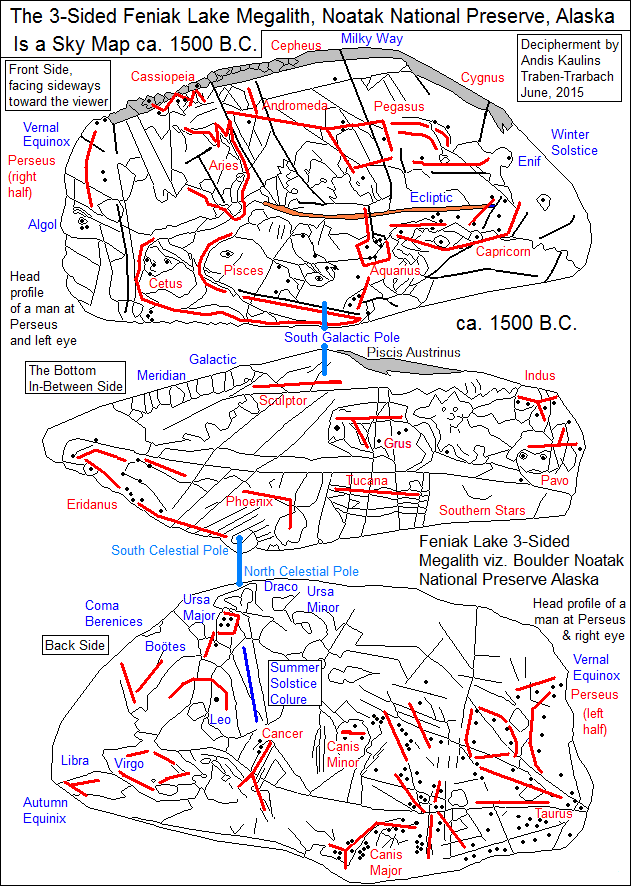
That applies particularly to our identification of the "rock art" of Feniak Lake in the Noatak National Preserve, which we  identify as marking the stars of Cetus  in the Native America land survey (and many other stars of course as well) -- see the next posting.

Did Noatak mark Cetus? One could, for example, argue that Noatak represents either the North Celestial Pole or the North Ecliptic Pole, as follows.

The Inuit Sky Culture entry at the Stellarium Wiki writes that:
"Nuuttuittuq is the North Star Polaris, the star that never moves."
Correctly seen astronomically, the heavenly center that never moves is the North Ecliptic Pole, whereas the North Celestial Pole does move, making a great circle around the North Ecliptic Pole in the course of ca. 26000 years. In our era Polaris marks the position of the North Celestial Pole. In other eras not. Nuuttuittuq could be viewed as being very similar to Noatak, but it is a stretch.

Donald J. Orth, Dictionary of Alaska Place Names suggests that the oldest English translation of Inland River for the Noatak River indicates that Noatak could have meant "new land" or "belong to the land" in view of Eskimo nunulak viz. nunatak as the presumed original terms preceding noatak, since nuna viz. nunu means simply "land".

But those obviously guessed "mainstream" etymologies ignore that the Eskimo term was translated as "Inland River" in spite of the fact that the Eskimo term for inland is kivva so that the general term nuna for "land" makes little sense here, as "tak" does not mean "inland". Alaska is a lot of "land", so that such a description without an additional describing term would be meaningless.

Orth (pp. 710-711) has nunamiut (originally perhaps Nunachogmute) for "land Eskimo". Nuna is such a frequent term it would hardly have been confused with Noa-, e.g. Mount Noak meaning "headland" (Orth, p. 692), which leads us to our own Noatak word analysis.

Possible in terms of word similarities and our decipherment below of the petroglyphic megaliths viz. boulders of Feniak Lake in the Noatak River region of Alsaka (68.273N 158.33W) as marking bright stars in the head of Cetus is that noatak could relate to Eskimo natchik meaning "seal", "hair seal" surely generic with Eskimo nutchat meaning "head hair" and niakuk "head". Cetus is a star group sometimes represented by a seal on megaliths, rather then the more modernly used "whale".
 
Hence, the Noatak River could arguably take its name from the name of the region, not from a concept of "inland" river, as all rivers are. That "inland" translation for the river name could have been convenient, but faulty.

We present our decipherment of one spectacular megalith of Feniak Lake "rock art" in the next posting.

See also megalithic.co.uk for more information on Feniak Lake.

In our coming decipherment we see Feniak Lake as representing the stars of Cetus -- and the 3-sided megalith that we decipher is quite amazing -- but it remains an identification which is provisional for now, and by no means certain, since there is thus far no probative evidence in the rock art itself to back it up.

THIS POSTING IS Posting Number 127 of
The Great Mound, Petroglyph and Painted Rock Art Journey of Native America

Alaska Rock Art Site Geographic Distribution Corresponds to Traditional Tribal Territorial Division

Tuesday, August 11, 2015

#Alphabet Number 1 Trend at Twitter: Are the People at Google Reading The Syllabic Origins of Writing and the Alphabet? Even if Not, We Are AGAIN Miles Ahead of the Trend!

#Alphabet is currently trending at Number 1 at Twitter.
Are people at Google reading
The Syllabic Origins of Writing and the Alphabet?
Even if Not, with ABCs we are AGAIN miles ahead of the trend.

Click the link for the print version
The Syllabic Origins of Writing and the Alphabet


Click the image above for the Kindle edition for Kindle, and the Amazon Kindle App for Android, iPad, iPhone

Saturday, August 08, 2015

Tuxedni Bay and Clam Cove Alaska Wall Carvings and Rock Art Pictographs Southwest of Anchorage Mark Stars in the Sky: Tuxedni is Cygnus and Clam Cove is Aquila But There is Much More

Unexpectedly, in a far north region where rock art is rare, the Tuxedni Bay and Clam Cove rock shelters of Alaska at Cook Inlet southwest of Anchorage  provide some of the most amazing pictographic rock art sites in North America.

Our decipherment of those two neighboring sites shows that these rock art sites are astronomy, with the pictographs arguably originating ca. 750 B.C. or 250 A.D. depending on how one views potential Solstice and Equinox markers  -- with the underlying wall carvings (as we see them) being much earlier in time, perhaps ca. 1750 B.C. or even earlier.

The Tuxedni pictographs, as deciphered below, do not cover one part of the sky -- the Winter Solstice to the Vernal Equinox -- but that part of the sky is then  covered by the Clam Cove pictographs. We see the underlying much older wall carvings at Tuxedni to cover also that part of the sky, but that is a different era.

We have previously deciphered a similar procedure of splitting the sky into two or more panels at the Eel River Slakaiya Rock Petroglyphs in California.

Tuxedni Bay Rock Shelter Pictographic Rock Art 
Shows the Starry Sky starting at the Summer Solstice at Cancer
(Wall Sequence = Left Group - Middle Group - Right Group)


The Individual Tuxedni Pictograph Groups
 
 The Left Group of Pictographs at Tuxedni Bay


The Middle Group of Pictographs at Tuxedni Bay


The Right Group of Pictographs at Tuxedni Bay


A Section of the Tuxedni Bay Rock Shelter Wall
Shows that Older Wall Carvings are Beneath
the More Recent Pictographic Rock Art on the Wall
From Vernal Equinox (at the left) to Winter Solstice (at the right)
Note how the pictographs "jump" from Taurus to Cygnus
That Section of the Sky from Winter Solstice to Vernal Equinox


The Neighboring Clam Cove Rock Shelter Pictographic Rock Art 
Shows the Same Section of the Sky in Pictographs
That is Missing from the Pictographs in the Above Image
(click on the graphic to obtain a larger image)

The Fornax/Sculptor star correspondence is a spectacular proof of the general correctness of the decipherment, also showing the rib-bone-type "ladder" to mark an area of the sky with no visible stars, a type of marker then also used in marking an area of empty space under Andromeda that points to the Vernal Equinox ca. 750 B.C.


According to our analysis, these sites mark stars in the heavens, with a focus on Cygnus viz. neighboring Lyra and Aquila in the land survey of Native America by astronomy. Carved figures and extensive pictographic rock art on site show even more stars, as the ancients present their artistic version of the heavens.

Linguistic analysis helped us here. How about that strange Eskimo name Tuxedni? The oldest name record version of Tuxedni (Donald J. Orth, Dictionary of Alaska Place Names, U.S. Government Printing Office, 1967) is Tukuzit (i.e Tu-Kuzit), and later given as Tuk-sed-ni, either of which would possibly fit Cygnus,  i.e Cygni as Sedni, or Kuzit arguably similar to the Arabic term Katat (Al Katat) an ancient Arabic term for Cygnus. We will never know of course for sure, but those terms are not that far off from the name Tuxedni.

We might also note for comparison the Indo-European e.g. Latvian tuksna, tuksnesis meaning "desert, wasteland" with the root of tuks- tukš- "empty" whence also tuksnītis meaning "anchoret, hermit".

The location of Tuxedni is just southwest of Anchorage, a city whose surely false name origin, as we read at CookInletHistory.org, is said to be as follows:
"Would-be entrepreneurs flocked to this bustling frontier town, and brought with them everything necessary to build a city. A popular hardware and clothing store, “The Anchorage,” was actually an old dry-docked steamship named “Bertha.”
 

Although the area had been known by various names, the U.S. Post Office Department formalized the use of the name “Anchorage,” and despite some protests, the name stuck."
That shows how folk etymologies develop, since the name "Anchorage" already existed before that, being called by the Russian name M[ys] Yakorniy "anchor cape"] as early as 1848. The Anchorage store may have been named after that, but the actual name origin of the place is earlier than that.

The Tuxedni Bay rock wall -- according to our graphic zoom image examination of photographs -- is sculpted to mark the stars. Those carvings are the oldest feature, dating by our analysis to ca. 1750 B.C. or perhaps even earlier. On top of those rock carvings, later pictographs (rock art, painted symbols) have been added in a different era -- which was likely ca. 750 B.C. or 250 A.D. judged by the more recent Winter Solstice marker on the wall of Tuxedni. Since our main concentration here was not on dating, those dates are provisional speculations.

We repeat here for the umpteenth time and emphasize again especially for the archaeological community that many if not most pictographic locations feature rock art that has been added at a later time on top of previously carved rocks. Many archaeologists seemingly do not appear to even consider this possibility, preferring to drill where drilling is easiest and looking only for what is most easily apparent.

Even the famous cave paintings at Lascaux and Chauvet in France are in our opinion painted on top of carved rocks, as we already noted years ago in our book, Stars Stones and Scholars: The Decipherment of the Megaliths.

Finding images online of the pictographs at Tuxedni Bay and neighboring Clam Cove, Alaska proved a daunting task until we found the book Where We Found A Whale: A History of Lake Clark National Park & Preserve, by Brian Fagan, Archeologist, National Park Service, which presents photographs and drawings of Tuxedni Rock Shelter in Chapter Five and Clam Cove in Chapter Six.

Those images allowed us to decipher essential segments of the Tuxedni Bay site and the Clam Cove Site, although even that book presents no complete single overview image of the pictographs at either site, so we have had to stitch them together from scattered photographic and illustrative pieces here and there. Let us know if we have made any significant errors in presentation of the material. Star positions used in the graphics have been calculated via Starry Night Pro http://astronomy.starrynight.com/.

Alaska’s Rock Art online relates the same marvelous story by Brian M. Fagan as found in the above book. As written there (excerpted below by us):

"The [Alaskan rock shelters of Tuxedni and Clam Cove] contain some of North America’s most intriguing rock art. [emphasis added here by us]

[At Tuxedni] "The red claw symbol set high on the rock face is immediately noticeable. It is a painting so prominent that it can be seen from a helicopter hovering overhead. Most visitors agree that it depicts a raven....

Melissa Baird identified 26 images, all painted with red ochre, scattered over an area about 4m long and 3m wide.... I first noticed a painting of a large, open skin boat like an Alutiiq angyap, with at least four crew members. Immediately to the left, a human figure with outstretched arms ... holds a club perhaps used in the hunt.... three images on its left, one of which may depict the oblong body of a whale. Another whale with a significant dorsal fin, perhaps a swimming whale breaching, completes the panel. [Annotation by Andis Kaulins: We identify those images [in the "Left Group"] as Taurus as the boat, Orion as the clearly drawn "male" human figure, Gemini as the two figures one above the other to the left of Orion, and Cancer as the figure to the left of Pisces.]
...

Another panel, set at 45 degrees, shows a swimming bird, perhaps a swan, its eye defined by a dark mark on the rock. A killer whale follows the bird, in turn pursued by a figure in a kayak. De Laguna thought the paddler was wearing a hunting helmet with a brim ‘like those worn . . . by the southern Eskimo and the Aleut.’ A short gap, then an anthropomorphic figure cavorts, with the usual outstretched arms and legs, but with a unique element: an unpainted circle in the middle of the torso.... An angyap-like boat, this time with a large crew, follows the human figure. [Annotation by Andis Kaulins: We identify those images [in the "Right Group"] as Sagittarius as a top-finned fish of some kind (dolphin?), Scorpio as a whale to its right, Libra as a kayak with a brimmed-hat paddler further to the right of the whale, the human figure with a circle in the torso as Virgo -- signifying the female, and the angyap-like boat as Leo.]

The paintings continue under a low overhang close to the ground.... It was a painting of an eyelike symbol, connected to ... [a number of] evenly spaced lines... like another image immediately to the right...." [Annotation by Andis Kaulins: This small group of petroglyphs helped to "prove" the correctness of our decipherment, as they had to be stars below Leo. We identify the left of those low images as the stars of Sextans with a row of stars above them pointing to the Summer Solstice (see the image further below), and the right fishbone-like image as representing a row of stars above the head of Hydra as if fixing the Ecliptic.]

[At Clam Cove] "The interior is deeper than Tuxedni, which is little more than a rock face – 7m deep and 9m wide.

The paintings are denser here, many of them close to a crack that separates the south and west walls. On the south wall, a large bird with outstretched wings, [emphasis added] perhaps a thunderbird, lies close to groups of human figures, one of them apparently waving rattles and perhaps dancing. The most interesting paintings lie on the west wall, among them a ladder-like sign with what appears to be a crab claw above it, and two human figures attached to the ladder’s top rung with a line.

The right hand figure is more abstract, with an object extending between its legs, perhaps two whale’s tails or a small human. I followed the jumble of images across the wall — mostly unidentifiable figures, except for an isolated profile of a quadruped, with ears and tail clearly shown. Nearby, two human figures and a whale cavort together, the human having the usual outstretched arms and legs, a grouping surrounded by a dashed line. An abstract figure below them wears some form of headdress and appears in profile, legs bent as if it is dancing. Baird thinks this may be a therianthrope, a beastlike human, for it is quite unlike any other human figure from the shelter.
Then the pictographs fade away to faded blobs. Dancing humans, breaching whales and, perhaps, memories of actual events: the images were immediate, yet elusive, their symbolism long vanished into history. All I could do was extrapolate from diverse sources of evidence."

THIS POSTING IS Posting Number 126 of
The Great Mound, Petroglyph and Painted Rock Art Journey of Native America

Tuxedni Bay and Clam Cove Alaska Wall Carvings and Rock Art Pictographs Southwest of Anchorage Mark Stars in the Sky: Tuxedni is Cygnus and Clam Cove is Aquila But There is Much More

Most Popular Posts of All Time

Sky Earth Native America


Sky Earth Native America 1:
American Indian Rock Art Petroglyphs Pictographs
Cave Paintings Earthworks & Mounds as Land Survey & Astronomy
,
Volume 1, Edition 2, 266 pages, by Andis Kaulins.

  • Sky Earth Native America 2:
    American Indian Rock Art Petroglyphs Pictographs
    Cave Paintings Earthworks & Mounds as Land Survey & Astronomy
    ,
    Volume 2, Edition 2, 262 pages, by Andis Kaulins.

  • Both volumes have the same cover except for the labels "Volume 1" viz. "Volume 2".
    The image on the cover was created using public domain space photos of Earth from NASA.

    -----

    Both book volumes contain the following basic book description:
    "Alice Cunningham Fletcher observed in her 1902 publication in the American Anthropologist
    that there is ample evidence that some ancient cultures in Native America, e.g. the Pawnee in Nebraska,
    geographically located their villages according to patterns seen in stars of the heavens.
    See Alice C. Fletcher, Star Cult Among the Pawnee--A Preliminary Report,
    American Anthropologist, 4, 730-736, 1902.
    Ralph N. Buckstaff wrote:
    "These Indians recognized the constellations as we do, also the important stars,
    drawing them according to their magnitude.
    The groups were placed with a great deal of thought and care and show long study.
    ... They were keen observers....
    The Pawnee Indians must have had a knowledge of astronomy comparable to that of the early white men."
    See Ralph N. Buckstaff, Stars and Constellations of a Pawnee Sky Map,
    American Anthropologist, Vol. 29, Nr. 2, April-June 1927, pp. 279-285, 1927.
    In our book, we take these observations one level further
    and show that megalithic sites and petroglyphic rock carving and pictographic rock art in Native America,
    together with mounds and earthworks, were made to represent territorial geographic landmarks
    placed according to the stars of the sky using the ready map of the starry sky
    in the hermetic tradition, "as above, so below".
    That mirror image of the heavens on terrestrial land is the "Sky Earth" of Native America,
    whose "rock stars" are the real stars of the heavens, "immortalized" by rock art petroglyphs, pictographs,
    cave paintings, earthworks and mounds of various kinds (stone, earth, shells) on our Earth.
    These landmarks were placed systematically in North America, Central America (Meso-America) and South America
    and can to a large degree be reconstructed as the Sky Earth of Native America."


    Our Blogs and Websites

    • 99 is not 100 • Aabecis • AK Photo Blog • Ancient Egypt Weblog • Ancient World Blog • AndisKaulins.com • Andis Kaulins Blog • Archaeology Travel Photos (Flickr) • Archaeology Websearch • Archaeo Pundit • Arts Pundit • Astrology and Birth • Baltic Coachman • Biotechnology Pundit • Book Pundit • Chronology of the Ancient World • Easter Island Script • Echolat • edu.edu • Einstein’s Voice • Etruscan Bronze Liver of Piacenza • EU Pundit • Gadget Pundit • Garden Pundit • Golf Pundit • Gourmet Pundit • Hand Proof • House Pundit • Human Migrations • Idea Pundit • Illyrian Language • Indus Valley Script • Infinity One : The Secret of the First Disk (the game) • Isandis (blogspot) • Journal Pundit • Kaulins Genealogy Blog • Kaulinsium • Latvian Blog • LawPundit.com • LawPundit (blog I) • Law Pundit (blog II) • LexiLine.com • Lexiline Journal • LexiLine (ProBoards) • Library Pundit • Lingwhizt • Literary Pundit • Magnifichess • Make it Music • Maps and Cartography • Megalithic World • Megaliths • Megaliths.net • Minoan Culture • Mutatis Mutandis • Nanotech Pundit • Nostratic Languages • Phaistos Disc • Pharaonic Hieroglyphs • Photo Blog of the World • Prehistoric Art Pundit • Private Wealth Blog • PunditMania • Quanticalian • Quick to Travel • Quill Pundit • Road Pundit • Sport Pundit • Star Pundit • • Stars Stones and Scholars (blog) • Stars Stones and Scholars (book) • Stonehenge Pundit • The Enchanted Glass • UbiquitousPundit • WatchPundit • Wine Pundit • Word Pundit •