Saturday, March 28, 2015

Crystal River Mounds of the Crystal River Archaeological State Park in Florida Mark Stars at the Head of Cetus

The most significant site for reconstructing the land survey in the Florida Peninsula was the Crystal River Archaeological State Park with its well-known Crystal 
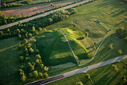
River Mounds, where it is written online that "The 14 acre six mound complex [actually, more, since some mounds appear conjoined] is one of the most imposing prehistoric ceremonial centers on Florida's west coast."

The Wikipedia writes at the entry for Crystal River Archaeological State Park that:
"Crystal River State Archaeological Site ...[u]nder the title of Crystal River Indian Mounds ... is ... a U.S. National Historic Landmark (designated as such on September 29, 1970)."
As written by Dale Cox at Explore Southern History in The Crystal River Archaeological State Park: Prehistory on the Crystal River:
"[T]he two great platform mounds ... appear to be part of a planned alignment ... a giant astronomical observatory. It is thought that the placement of the mounds could be used to track the seasons by the way they aligned with the sun and other stars at different times of the year.... [a] feature [that] can also be seen at a number of other prehistoric mound complexes....

Of particular interest at Crystal River are two mysterious stone stele or monuments. They align with the mounds and one even features a faded carving of a human face...."
That is one of the few observations we have seen anywhere, other than in our work, that the mounds have astronomical significance in the stars. Bravo!

The Crystal River site in the ancient land survey of Native America marks the star Gamma Ceti, but the site itself is marked by mounds which are deciphered by us below as marking the "head" stars of Cetus.

Cetus is a star group (asterism) with a similar heavenly form even in distant Chinese astronomy, where it is viewed as a circular celestial granary.

Of interest in that regard is that the somewhat distant "Temple" Mound represents the binary star Xi1 Ceti, as written at the Wikipedia:
"Xi1 Ceti1 Ceti), is a binary system located in the constellation Cetus, suspected as a ternary. In Chinese, 天囷 (Tiān Qūn), meaning Circular Celestial Granary, refers to an asterism consisting of α Ceti, κ1 Ceti, λ Ceti, μ Ceti, ξ1 Ceti, ξ2 Ceti, ν Ceti, γ Ceti, δ Ceti, 75 Ceti, 70 Ceti, 63 Ceti and 66 Ceti. Consequently, Xi1 Ceti itself is known as the Fifth Star of Circular Celestial Granary, Tiān Qūn Wu.[3]"
The binary nature of that star could account for the elongated shape of the mound as marking "two" stars as it were. The central mound is similar, marking a "triple star" and maps have shown sort of a multiple CDE mound there. We show the decipherment of the Crystal River Mounds below.


Our analysis indicates that the megaliths -- called stelas viz. steles in the literature -- marked the colure, i.e. line of the Equinoxes in ca. 1150 B.C., but the issue of dating is not critical here to the identification of the mounds as stars of in the head of Cetus. We will examine Stela #1 in the next posting.


THIS POSTING IS Posting Number 50 of
The Great Mound, Petroglyph and Painted Rock Art Journey of Native America 


Crystal River Mounds of the Crystal River Archaeological State Park in Florida Mark Stars at the Head of Cetus

Ancient Mounds of the Florida Peninsula Mark the Stars of Cetus -- Crystal River Mounds, Horr's Island (now the "other" Key Marco), Miami Circle and More

The ancient mounds of what we today call Florida mark the stars of Cetus, being, however, limited to the Peninsula. The (apparently younger) mounds in what today is the Florida Panhandle are not included in this representation.

Our last decipherments covered Perseus, the Pleiades and Aries and since Florida is below Alabama by latitude, the only stars that would have come into question for Florida in the ancient land survey would have been Cetus and Pisces, and so it is in fact, with the emphasis fully on Cetus, which permits a more vertical southward presentation of the Florida Peninsula, something which would be difficult using the relatively faint and mainly horizontal stars of Pisces.


As can be seen, the Crystal River Mounds mark the star Gamma Ceti,
a triple star,
thus perhaps explaining the thus far unresolved "triple" nature of its mound at the Crystal River Mounds
-- which, all taken together, mark stars at the head of Cetus.
We decipher the Crystal River Mounds in the next posting so as not to overburden this posting with another large graphic image.

The Horr's Island archaeological site has only four mounds, but they were important for placing Horr's Island properly in the full Florida decipherment above, thus revealing to a greater degree which stars were marked by the other Florida sites. We have placed the four-mound pattern in the map above and do not decipher these mounds separately, because it is otherwise very clear.

As we have deciphered it, the four mounds of Horr's Island (the newer "Key Marco") mark Tau Ceti and three additional prominent nearby stars at 46, 47 and 50 Ceti, which are all of star magnitude 5.50 of brighter, the only such stars in the entire interior of Cetus.

Horr's Island mound location is based on a map in William N. Morgan, Precolumbian Architecture in Eastern North America, (Florida Museum of Natural History: Ripley P. Bullen Series), University Press of Florida, 1999, ISBN 0-8130-1659-2. The decipherment of the stars marked by the mounds is of course, as always, by Andis Kaulins, who is not affiliated with any of the named persons or organizations.

The ancients were able to recognize top real estate locations. The former Horr's Island archaeological site is just a stone's throw away from Naples, Florida, one of the most expensive residential communities in the modern United States.

Horr's Island, home of Horr's Island archaeological site, was modernly and perhaps understandably renamed some year ago, but the new name of "Key Marco" created a confusion with a different Key Marco archaeological site

The Wikipedia writes about the name confusion:
"The Horr's Island archaeological site is a significant Archaic period archaeological site located on an island in Southwest Florida formerly known as Horr's Island. Horr's Island (now called Key Marco, not to be confused with the archaeological site Key Marco) is on the south side of Marco Island in Collier County, Florida. The site includes four mounds and a shell ring. It has one of the oldest known mound burials in the eastern United States, dating to about 3400 radiocarbon years Before Present (BP). One of the mounds has been dated to as early as 6700 BP. It was the largest known community in the southeastern United States to have been permanently occupied during the Archaic period (8000 BCE-1000 BCE)."
The Wikipedia writes about the "other" Key Marco:
"The island of Key Marco was composed of shell mounds and other shell works and separate from Marco Island in the 19th century. A late 19th century settlement on the island was called Marco Village.... By late in the 20th century Key Marco had been attached to Marco Island and all of the mounds on Key Marco had been leveled and built on. The area is now known as Old Marco Village. One source of confusion ...  arises from the fact that in the 1980s a development company renamed the former Horr's Island as "Key Marco". Horr's Island was the location of an independently significant archaeological site. It has one of the oldest indigenous burial mounds of the eastern United States, dating to about 1450 BCE; and it was the site of the largest, permanently occupied community of the Archaic period (8000 BCE- 1000 BCE) in the southeastern part of the nation."
Note in the map above that the Miami Circle marks Beta Ceti, Deneb Kaitos, also known as Diphda, the brightest star in Cetus, known in Chinese astronomy as the "superintendent of earthworks" (Star Names, Richard Hinckley Allen) viz. "master of constructions", and such it may have been in Miami, as a possibly circular triangulation fulcrum for the ancient land survey of Native America by astronomy. Diphda marks the lowest point that the celestial equator can reach in this part of the heavens, which happens only once every ca. 26,000 years.

We will return to the Miami Circle in a later posting. The next posting is on our Crystal River Mounds decipherment, mounds which are shown to mark the stars at the head of Cetus.

THIS POSTING IS Posting Number 49 of
The Great Mound, Petroglyph and Painted Rock Art Journey of Native America


Ancient Mounds of the Florida Peninsula Mark the Stars of Cetus -- Crystal River Mounds, Horr's Island (now the "other" Key Marco), Miami Circle and More

Friday, March 27, 2015

The Bottle Creek Mounds North of Mobile Alabama Mark the Stars of the Pleiades

We knew from our analysis and decipherment of the Shelton Stone Mound Complex near Jacksonville, Alabama that a mound group in southern Alabama was likely to mark the stars of the Pleiades, and so it is.

The Bottle Creek Indian Mounds were designated a National Historic Landmark in 1994, and, according to the Wikipedia entry, comprise "the largest site of the Mississippian culture on the central Gulf Coast". The site is currently somewhat remote to reach, but perhaps in the ancient period access was easier.

According to our analysis, the Bottle Creek Mounds in southern Alabama, north of Mobile, mark the stars of the Pleiades, as one can see from our following decipherment image.

The mound positions are based on an online map of Bottle Creek from the Center for Archaeological Studies, University of South Alabama, Mobile, Alabama http://www.southalabama.edu/archaeology/bottle-creek-map.html. Star positions are based on the astronomy software program, Starry Night Pro.


We have set the star magnitude limit at 7.25 so that the stars shown in our decipherment image are the only stars visible in that clipped section of the starry sky when limited to that magnitude. The presentation of the Pleiades is not exact to scale at Bottle Creek, but the overlap of mounds and stars is of course fantastic, nevertheless. Some of the smaller stars are not "mounded" in part because they are so close to bright stars that they are probably blotted out to the naked eye. That leaves only one star at star magnitude 7.25 or brighter within the Pleiades cluster not accounted for by a mound, probably because of the nearby water, which already forced Mounds F and G to be constructed a bit nearer to the mounds of the brightest stars than those lesser stars actually are.

Looking at the stars at that magnitude also explains the inclusion of the stars HIP18508 and HIP18559 as the Mounds O and R, somewhat distant from the central Pleiades cluster, since they marked the line of the Ecliptic Meridian in 2500 B.C., a date to which we assign the initial layout of the site, even if it were occupied much later by the Pensacola culture, for whom Bottle Creek was the center of the culture. At a star limit magnitude limit of 7.25, there are no stars between those two stars and the main Pleiades cluster.

Please note that our dating of the mound layout is not critical for the actual identification of the stars represented by the mounds. We could err on the date, but in this case, never on the stars represented, which is a lock.

There is very little likelihood that this kind of a match of mounds and stars of the Pleiades could occur by chance, especially since it also involves nearly all the brightest stars of the Pleiades being marked by the larger mounds and the lesser stars being marked by lesser mounds, as one would expect, although that match is not always perfect, perhaps because star brightness can be variable.

Lastly, based upon all of our previous decipherments, the Pleiades properly occupy this location in the ancient continental Native America land survey by astronomy.

THIS POSTING IS Posting Number 48 of
The Great Mound, Petroglyph and Painted Rock Art Journey of Native America


The Bottle Creek Mounds north of Mobile, Alabama Mark the Stars of the Pleiades

Thursday, March 26, 2015

Flinders Petrie and the Shelton Mound Wall and Boulder Complex Groups 1 2 3 Together as a Weaver & Vertical Warp-Weighted Backstrap-Type Loom

Perseus in the stars is magnificently shown by a weaving-related image from Beni Hasan in Ancient Egypt. The image is the frontspiece cover to Flinders Petrie, ed., Ancient Egypt, Part IV, Henry Ling Roth and Grace Mary (Molly) Crowfoot, Models of Egyptian Looms, MacMillan and Co., London & New York and Egyptian Research Account, Chicago, 1921, which we found online via Handweaving.net at http://www.handweaving.net/document-detail/3202:


Well, folks. That quite unusual raised-leg "spinning" figure with distaffs out of Ancient Egypt is the shape of Perseus. Indeed, why else raise that leg there, standing on a pedestal? The image speaks for itself for purposes of our discussion in this posting and those immediately previous. The Pharaonic Egyptian Goddess of Weaving was the all-important deity Neith:
"In pre-Dynastic Egypt, Neith [nt, nit] was already the goddess of weaving.... She protected the Red Crown of Lower Egypt before the two kingdoms were merged, and in Dynastic times she was known as the most ancient one, to whom the other gods went for wisdom. Neith is identifiable by her emblems: most often it is the loom's shuttle, with its two recognizable hooks at each end, upon her head. According to E. A. Wallis Budge (The Gods of the Egyptians) the root of the word for weaving and also for being are the same...."
Compare as an image the modern Merriam-Webster image of a distaff and spindle http://www.merriam-webster.com/art/dict/distaff.htm.

Let us now turn to the Shelton Complex. Taken as a whole, the ancient mounds, walls, boulders and stone circle of Groups 1, 2 and 3 of the Shelton Stone Mound Complex near Jacksonville, Alabama,
-- as deciphered individually in our previous postings --
indicate that the Shelton Complex not only marked the stars of Camelopardalis, Perseus, the Pleiades and Aries, but had a further function, which was to "immortalize" in the sky the figure "drawn" in those stars, a heavenly sky figure whose Perseus name is similar to Perchta, the Germanic goddess of Spinning and Weaving, about whom we will write a bit later.

As seen in our decipherment image below, we think that the 3 groups of mounds, boulders and walls at the Shelton Stone Mound Complex taken together represent a human figure seated at an ancient Neolithic ("Stone Age") vertical warp-weighted backstrap-type weaving loom:


Stone mound, wall and boulder locations above are based on maps at Harry O. Holstein, Ph.D., Preliminary Investigations at the Shelton Stone Mound Complex, 1CA637, Calhoun County, Alabama -- Jacksonville State University, Archaeological Resource Laboratory, Research Series No. 3, February 2007, Maps by Jacob Kohute, Graphic Design, Layout and Editing by Valerie Glesner and Rebecca Turley Ridley -- Made Possible by a Faculty Research Grant Provided by Dr. Rebecca Turner, Vice President of Academic Affairs.

In our image decipherment above we have a thumb of Figure 19, "A native loom whose design is common to many parts of the world, and which uses only those materials available in the neighbourhood", from Abbott Payson Usher, A History of Mechanical Inventions, Harvard University Press, 1954, as we found online at Doorway Papers by Arthur B. Custance.

Our image decipherment above also has a thumb of a Chinese silk spinner.

We have provisionally labeled the physical position of the weaver, head, torso, hip, arms and hands, and legs and feet, as also the weighted warp (with tension marks), the warp beam or equivalent, the warp tension or distribution mechanism (heddles ?), including also a rope from the weight to the movable hip area (similar to a backstrap loom), the stick shuttle, the beater viz. batten, the shed and weft insert location, the treadle and the swift viz. cloth take-up.

We emphasize that our detailed explanation is "provisional" because we are novices at the weaving and spinning crafts and have never ourselves used a loom or weaved a single cloth. We leave final analysis of the deciphered figure and the weaving details to experts in the weaving industry.

Needless to say, nevertheless, all the Sheldon Stone Mound Complex stone mounds, walls, and boulders -- as chosen by the ancients to represent certain stars -- even though many other star options were available in this part of the sky to them -- must have helped to fulfill representation of a particular loom viz. weaving function, of that we are sure. Hence, we assume e.g. that three lines in two instances mark three warps or wefts and that the "movable" sitting position and leg motion is marked by "wavy" lines. But that is speculative.

We did an immense amount of reading to become minimally familiar enough with ancient looms and weaving to venture the above graphic image explanation of the alleged loom representation in the stars.

For those similarly situated, below is some of what we learned.

Early in the course of the civilization -- perhaps while developing bast fibre basketry or working with animal hides -- humans in need of protective clothing discovered the principle of textile weaving.

Textiles were "woven" by taking one or more sets of "stringed" longitudinal viz. lengthwise material (yarns, threads, the so-called "warp" in weaving)
and "interweaving" them perpendicularly viz. transversely
with other yarns or threads (the so-called "weft", "fill" or "filling yarn")
thus creating in the process what we call "cloth" for "clothing".

That was basically the prehistoric birth of the textile industry, the largest industry in the world clear up to the modern 15th century.

There appears to be no agreement in the mainstream literature, however, as to when exactly that happened time-wise, although there is every indication that warp-weighted looms or similar basic looms go clear back into the Neolithic era, being possibly evidenced in the Starčevo culture ca. 7500 years ago, and also at Çatal Hüyük, though this is disputed.

Spinning and weaving apparatus are well known in Ancient Egypt. As written at Alfred Lucas and J.R. Harris in Ancient Egyptian Materials and Industries:
"Spinning and weaving were among the oldest of the crafts practised in Egypt, and woven fabrics from as early as the neolithic period have been found."
The authors cite to G. Caton Thompson and E.W. Gardner in Desert Fayum. We are therfore on very solid ground historically in alleging the existence of ancient weaving apparatus worldwide.

The figure at the beginning of this posting is from Beni Hasan, not far from Minya, Egypt, ca. 150 miles south of Cairo, and we have long held the opinion that the Minyans were the people who surveyed the Earth in ancient days, a task that came down to us over the millennia as Jason and the Argonauts.

Some of the "functions" that we have assigned in our image above we obtained from some of the sources cited below.

See an excellent and helpful schematic drawing of weaving at Uttu Textiles Design and Innovations. Turn that image 90 degrees and it will help you to better understand the decipherment image above.

Carolyn Priest-Dorman at Vassar has a page of Textile Resources as well as some sources on the Warp-Weighted Loom.

How a backstrap loom functions can be read at Backstrap Weaving.

Maya Bags writes at Rediscovering the back-strap loom:
"Like embroidery, back-strap looming to create textiles has been a highly valued skill since the Maya Classic period, over 2000 years ago. Back-strap looming is a unique form of weaving. One end of a loom is traditionally attached to a wall or a tree and the other end is strapped on the weaver’s back with a strap made of fibers from the agave plant. As the woman pushes her hips forward and back, she raises and lowers the heddle stick. This allows her to push another strand of yarn from right to left (the weft) through the yarns that make up the warp or vertical layout of yarns."
See photographs of ancient weaving techniques at "First People", A Navaho Woman Weaving at Loom.

See Pro-Ecuador.com for Ecuador Real Estate Tour Visits Peguche Weavers.

See a relatively modern weaver from Nürnberg, Germany, c. 1425 A.D.

See Lennie and Weaving the World of Ancient Mayan Women at  ancient-origins.net

See a schematic figure of a loom at Silk Mark India.

Now what about Pferchta? Was Perseus the same as Pferchta viz. Bertha in ancient days? The Wikipedia writes that Pferchta:
"[W]as known as a goddess who oversaw spinning and weaving, like myths of Holda in Continental German regions.... In many old descriptions, Bertha had one large foot, sometimes called a goose foot or swan foot. Grimm thought ... "It is apparently... the spinning-woman's splayfoot that worked the treadle"".
That describes the stars of Perseus well, which show a figure whose "legs" are of different lengths....

The Wikipedia relates regarding Weaving mythology that:
"In Germanic mythology, Holda (Frau Holle) and Perchta (Frau Perchta, Berchta, Bertha) were both known as goddesses who oversaw spinning and weaving. They had many names."
So what about those names? Let us look at the etymological origin of the term Pferchta, whose purported etymology as related at the Wikipedia article cited above can mostly be dismissed as completely unsupported folk etymology.

RATHER, being a German speaker, we can relate that the term pferchen in German means "to jam together", often said of people and animals, which "jamming" is the "end" product of weaving, whereby the warp and the weft are "beaten" together with a "batten", i.e. jammed together, to form the cloth.

The German term pferchen in turn is surely related to German (p)flechten, which means "to braid", i.e. "weaving" in this sense, to which we have English comparables plait and pleat, i.e. "fold" and thus Low German pletten "to iron clothes".

We might add -- speculatively -- in another case of etymology here, that the origin of the name of the State of Alabama is unknown and disputed, in spite of some clever folksy etymologies one can find online. 

We think that the name of Alabama comes from the brightest star in Perseus, Alpha Persei, normally called Mirfak or Algenib, whose name in ancient sources is also given as the ancient Alchemib -- which could easily have developed into Alabama through linguistic metathesis.

THIS POSTING IS Posting Number 47 of
The Great Mound, Petroglyph and Painted Rock Art Journey of Native America


Flinders Petrie and the Shelton Mound Wall and Boulder Complex Groups 1 2 3 Together as a Weaver & Vertical Warp-Weighted Backstrap-Type Loom

Tuesday, March 24, 2015

The Shelton Stone Mound Complex Group 3 near Jacksonville Alabama Marks the Pleiades and Stars of Aries

The Shelton Stone Mound Complex Group 3 near Jacksonville Alabama marks the Pleiades and stars of Aries, with the stone boulder marking the Pleiades and the half-curved wall around the boulder marking well the stars around them.


So what does it all mean?

Now try putting groups 1, 2 and 3 all together as ONE figure and figure out what that expanded figure is doing, which should not be a "backstrapping" task, now, should it?

THIS POSTING IS Posting Number 46 of
The Great Mound, Petroglyph and Painted Rock Art Journey of Native America


The Shelton Stone Mound Complex Group 3 near Jacksonville Alabama Marks the Pleiades and Stars of Aries

The Shelton Stone Mound Complex Group 1 near Jacksonville Alabama Marks Primarily Stars of What We Today Call Camelopardalis Above Perseus

If Group 2 of the the Shelton Stone Mound Complex near Jacksonville Alabama marks primarily stars of Perseus, then it was likely that Group 1 of stone mounds and walls in that same Complex to the north likely marked stars of what we today call Camelopardalis, and so it is.


We will get to what that "design" may mean in the posting after the next, which handles Group 3.

THIS POSTING IS Posting Number 45 of
The Great Mound, Petroglyph and Painted Rock Art Journey of Native America

The Shelton Stone Mound Complex Group 1 near Jacksonville Alabama Marks Primarily Stars of What We Today Call Camelopardalis Above Perseus

The Shelton Stone Mound Complex Group 2 near Jacksonville Alabama Marks Stars of Perseus

The Shelton Stone Mound Complex located at ca. 33°48'57"N 85°45'38"W consists of 3 groups of mounds, walls, boulders and a boulder circle, located east of Jacksonville, Alabama.

We present here our decipherment of Group 2 as marking stars of Perseus.

As a member of ResearchGate we downloaded and examined the major applicable publication by Harry O. Holstein, Ph.D., Preliminary Investigations at the Shelton Stone Mound Complex, 1CA637, Calhoun County, Alabama, Jacksonville State University ["JSU"], Archaeological Resource Laboratory ["ARL"], Research Series No. 3, February 2007, maps by Jacob Kohute, graphic design, layout and editing by Valerie Glesner and Rebecca Turley Ridley, a publication made possible by a faculty research grant provided by Dr. Rebecca Turner, Vice President of Academic Affairs. We have no affiliation with the above-named institutions or persons.

The map, graphic design and financing deserve the mention we give to them above. In our own illustrated decipherment image below, we rely on the mound, wall and other locations on those maps in Holstein's publication.

The Shelton Stone Mound Complex, located just east of Jacksonville, Alabama, is named for A.C. Shelton, property owner of most of the site, together with adjacent USFS property. As written in the Abstract to Holstein's publication:
"In February and August of 2006, the Jacksonville State University (JSU) Archaeological Resource Laboratory (ARL) conducted field investigations at the Shelton Stone Mound Complex, 1Ca637, which straddles the eastern slope of Choccolocco Mountain overlooking Whites Gap in eastern Calhoun County, Alabama. The majority of the stone mound complex is located on the property of  A.C. Shelton, with a portion extending into adjacent USFS property. The site, at present, consists of 79 conical stone mounds, one horseshoe-shaped mound, 31 linear stone walls, a serpent-like stone wall, one “Z” –shaped stone wall with natural boulder feature, one “V”- shaped stone wall, and an oval boulder configuration. JSU-ARL researchers, based on early historical records and comparative site information, believe these stone structures were constructed during the Woodland period, 1000 BC to AD 600."
Our decipherment is found in the image below:


Star positions above are shown via the software astronomy program Starry Night Pro, to which we have added many mostly colored lines and comments.

As one can see above, the image formed by the stars selected by the ancients in Native America seems to illustrate Perseus as a figure doing "something". What could it be?

We were particularly puzzled that some stars and groups of stars were marked somewhat unusually by walls rather than stone mounds. Why that? Also the role of the two isolated boulders and the boulder circle appeared completely mysterious, that is, until we deciphered also Groups 1 and 3 of the same Shelton Stone Mound Complex, which gave us an idea about the figure and the activity represented.

The next three postings cover the following related decipherments:
  • Shelton Stone Mound Complex Group 1 mounds and walls show stars upward from Perseus to stars in a constellation we today call Camelopardalis.
  • Shelton Stone Mound Complex Group 3 mounds and walls show stars under Perseus toward and including Aries.
  • And then we put all three groups together, with a spectacular and also for us, totally unexpected, result.
Contrary to the present provisional mainstream dating of the Complex to the Woodland period, i.e. at the earliest 1000 B.C., we provisionally date the Shelton Complex to ca. 2500 B.C. based on our interpretation of our own decipherment of the site, which appears to show marked astronomical parameters such as celestial meridian, ecliptic meridian, celestial equator and ecliptic. The dating issue is not, however, critical for our astronomical decipherment of the stars as marking Perseus, which is absolutely clear.

THIS POSTING IS Posting Number 44 of
The Great Mound, Petroglyph and Painted Rock Art Journey of Native America

The Shelton Stone Mound Complex Group 2 near Jacksonville Alabama Marks Stars of Perseus: Astronomical Celestial & Ecliptic Parameters May Date the Complex to ca. 2500 B.C.

Moundville Earth Mounds near Tuscaloosa Alabama Mark Stars of Perseus

This posting is a decipherment showing that Moundville earth mounds near Tuscaloosa, Alabama, mark stars of what we today call Perseus.

If mounds in eastern Louisiana and western Mississippi mark the stars of Auriga in the ancient Native America land survey by astronomy, then mounds to the East in Mississippi and Alabama can only mark the stars of Perseus, and so it is.

Indeed, in our decipherments we have not one, but TWO comprehensive sites with many, many mounds that leave absolutely no doubt about that conclusion.

Let us first take a look at Moundville Archaeological Park near Tuscaloosa, Alabama, and then in the subsequent posting we will examine the lesser known, and only relatively recently archaeologically examined, Shelton Stone Mound Complex in eastern Calhoun County to the east of Jacksonville, Alabama.

The Wikipedia recites about Tuscaloosa, Alabama history:
"Nearly 12,000 years ago, Native Americans or Paleo-Indians arrived in what today is referred to as the Deep South. Paleo-Indians in the South were hunter-gatherers who pursued the megafauna that became extinct following the end of the Pleistocene age. After thousands of years, the Paleo-Indians developed a rich and complex agricultural society. Archaeologists called these people the Mississippians of the Mississippian culture; they were Mound Builders. Their large earthworks, built for political and religious rituals and expressing their cosmology, still stand throughout the valleys of the Ohio and Mississippi rivers, as well as their tributaries in the Southeast."
Moundville is an important mound site of Native America. As written in the Abstract to Archaeology of the Moundville Chiefdom, Smithsonian Series in Archaeological Inquiry, University of Alabama Press, 2006, Vernon J. Knight (Editor):

"At its height the Moundville ceremonial center was a densely occupied town of approximately 1,000 residents, with at least 29 earthen mounds surrounding a central plaza. Today, Moundville is not only one the largest and best-preserved Mississippian sites in the United States, but also one of the most intensively studied. This volume brings together nine Moundville specialists who trace the site’s evolution and eventual decline."
The Wikipedia writes at Moundville Archaeological Site:
"Moundville ... was the political and ceremonial center of a regionally organized Mississippian culture chiefdom polity between the 11th and 16th centuries. The archaeological park portion of the site is administered by the University of Alabama Museums and encompasses 185 acres (75 ha), consisting of 29 platform mounds around a rectangular plaza. The site was declared a National Historic Landmark in 1964 and was added to the National Register of Historic Places in 1966.
Moundville is the second-largest site in the United States of the classic Middle Mississippian era, after Cahokia in Illinois. The culture was expressed in villages and chiefdoms throughout the central Mississippi River Valley, the lower Ohio River Valley, and most of the Mid-South area, including Kentucky, Tennessee, Alabama, and Mississippi as the core of the classic Mississippian culture area. The park contains a museum and an archaeological laboratory."

Moundville Archaeological Park near Tuscaloosa, Alabama, opens its online presence by urging visitation, writing:
"Moundville Archaeological Park is just 14 miles south of Exit 71-A on Interstate 59/20."
There is also understanding expressed for the systematic nature of the location of the mounds:
"Of the two largest mounds in the group, Mound A occupies the center of the great plaza, and Mound B lies just to the north on the site’s central axis. The latter is a steep pyramid with two ramps, rising to a height of fifty-eight feet. The arrangement of the mounds and plaza gives the impression of symmetry and planning."
How right they are!

The entire complex, as shown in our simplified decipherment map below, which has no affiliation to any of the above or below named persons or institutions, marks the stars of Perseus.

The position of the mounds in our illustration relies on mound locations shown in Moundville online maps at the Research Laboratories of Archaeology at http://rla.unc.edu/mdvl/maps.html, while the corresponding star positions are given via the astronomy software program Starry Night Pro. See http://astronomy.starrynight.com.


The entire image suggests that the ancients viewed Perseus as a seated figure. This general representation is confirmed in what we view to be the much older Shelton Stone Mound Complex in eastern Calhoun County to the east of Jacksonville, Alabama, which we decipher in the next posting.

THIS POSTING IS Posting Number 43 of
The Great Mound, Petroglyph and Painted Rock Art Journey of Native America

Moundville Earth Mounds near Tuscaloosa Alabama Mark Stars of Perseus

Friday, March 20, 2015

Marksville Emerald Mound and 46 Locations in Louisiana and Mississippi Mark Stars of Auriga: The Indian Trail Natchez Trace Thus Followed the Edge of the Milky Way

The Native America(n) "Indian" mounds of Louisiana and in part Mississippi below the Toltec Mounds of Arkansas mark primarily stars of Auriga, as shown in the graphic image below. The Natchez Trace, the most famed of the Indian Trails, is thus shown to have followed the edge of the Milky Way in the stars.

The mounds in the graphic image below for which there are corresponding stars in Auriga (with a few exceptions in Taurus) are the Winterville Mounds, which at the top of the map illustrations mark Theta Aurigae and nearby stars, Jaketown, Galloway Place Mound, Mott Mounds (presumably Hoedus I, II and nearby stars, but the mound locations are unclear), Hedgepeth Mounds, Scott Place Mounds, Venable Mound, Caney Bajou Mound, Watson Brake Mounds, Filhiol Mound, Landerneau Mounds, Poverty Point Earthworks [which is in Auriga for the continental system, but used locally for astronomical calculation in the Pleiades], Julice Mound, Transylvania Mound, Lower Jackson Mound, Marsden Mounds, Tendal Mound, Schicker Mound, Insley Mounds, Fitzhugh Mounds, Shackleford Church Mounds, Wade Landing Mound, Ghost Site Mounds, Balmoral Mounds, Mayflower Mound, Sundown Mounds, Flowery Mound, Mound Plantation, Magnum Mound, Boothe Landing Mound, Alexander Mound, Harrisonburg Mounds, McGuffee Mounds, Tew Lake Mounds, Routon Mounds, Troyville Earthworks, Peck Mounds, Lamarque Landing Mound, Cypress Grove Mound, Crooks Mound, Churupa Plantation Mound, Frogmore Mound, Emerald Mound (the right corner star of Auriga, Hassaleh, and nearby stars), Natchez Trace, Grand Village of the Natchez, Marksville (marking Elnath, the left corner star of Auriga, assigned incomprehensibly to Taurus by modern astronomers, and nearby stars), Boyd Mounds and LSU Campus Mounds (which are clearly in Taurus).


The Emerald Mound is described at the National Register of Historic Places. The Wikipedia writes:
"The Emerald Mound Site is a Plaquemine Mississippian period archaeological site located on the Natchez Trace Parkway near Stanton, Mississippi, United States. The site dates from the period between 1200 and 1730 CE. The platform mound is the second-largest Pre-Columbian earthwork in the country, after Monk's Mound at Cahokia, Illinois. The mound covers eight acres, measuring 770 by 435 feet at the base and 35 feet in height. Emerald Mound has a flat top with two smaller secondary mounds at each end. Travelers in the early 19th century noted a number of adjoining mounds and an encircling ditch that are no longer present. Emerald Mound was stabilized by the National Park Service in 1955. It was declared a National Historic Landmark in 1989."
Mound locations in the illustrations rely in part on Google Earth and in part on the Megalithic Portal and Megalith Map at http://www.megalithic.co.uk with whom we have no affiliation. The astronomical decipherments here have been independently made by Andis Kaulins, March, 2015, Traben-Trarbach.

If you go down far enough on the map to the two mounds on LSU (Louisiana State University) Campus, then those mounds without doubt represent stars in Taurus, but without decipherment of surrounding mounds, the identification of the exact stars corresponding to the LSU mounds would be just a pure guess.

We are grateful to, and wish to note specifically:
  • all those who contribute and have contributed to the Megalithic Portal and Megalith Map at http://www.megalithic.co.uk, as also the image overlay at Google Earth, which helped us greatly to decipher these sites. Thank you! The work would be much tougher without that info
  • the three-mound photograph at the Boyd Mounds at http://www.natcheztracetravel.com/natchez-trace-mississippi/canton-jackson-ms/173-boyd-mounds.html, which helped us to identify those stars, even though we still have no ground plan of the site available
  • several online illustrations of the mounds of the Emerald Mound which helped to identify it as marking the right corner star of Auriga, Hassaleh, and the nearby stars
  • the map illustration of the Mott Mounds online, though the actual location of these mounds still remains unclear, whence also making very provisional their assignment to Hoedus I and II and nearby stars, and
  • of course, the astronomy software program, Starry Night Pro, which makes this analysis possible, and without which, it would be impossible, and,
  • the ever-present Wikipedia, which provides us with data in our unquenching thirst for information about the mounds, rock art, cave paintings and petroglyphs of Native America
THIS POSTING IS Posting Number 42 of
The Great Mound, Petroglyph and Painted Rock Art Journey of Native America

Marksville Emerald Mound and 46 Locations in Louisiana and Mississippi Mark Stars of Auriga: The Indian Trail Natchez Trace Thus Followed the Edge of the Milky Way

The Winterville Mississippi Mounds Mark Theta Aurigae at Mound A and Nearby Stars in Auriga Lower than the Upper Toltec Mounds Star Menkalinan

We have some spectacular Cahokia-related postings coming up, but we insert here another simple mound and star correspondence posting to keep people on their toes and in awareness that the correspondences of stars to earthly mounds, simply because of the size of the latter and their unmistakable presence, comprise principal pieces of probative evidence in this entire field.

Plus, we have to get some detail into the discussion, and this posting does that. Our modus operandi is the idea that the sheer brunt of the evidence is going to start taking its toll even on the greatest of skeptics out there.

We previously posted that the Toltec Mounds in Arkansas marked the stars of Auriga, with the entire star group seen as a boat viz. canoe.

In the Native North America land survey by astronomy, the Toltec Mounds site marks the upper stars of Auriga, whereas mound locations geographically lower than that mark lower stars of Auriga.

The Winterville Mounds in Mississippi are a good example of how the stars of Auriga are marked below the Toltec Mounds.

The Wikipedia writes:
"The Winterville ceremonial center originally contained at least twenty-three platform mounds surrounding several plazas. Some of the mounds located outside the park boundaries were leveled by highway construction and farming before the site became protected as Winterville State Park. Twelve of the site's largest mounds, including the 55 feet (17 m) high Temple Mound, are the focus in the early 21st century of a long-range preservation plan being developed by the Mississippi Department of Archives and History and the University of Mississippi's Center for Archaeological Research."
As one can see from our decipherment in the image below, the Winterville Mounds unmistakeably mark the star Theta Aurigae at the largest mound (Mound A) and mark nearby stars in Auriga at the other mounds, with Mound K corresponding to Upsilon Aurigae and Mounds G and H corresponding to Nu Aurigae and Tau Aurigae respectively.

Mound C marks 40 Aurigae, which has three stars to its right leading to Nu and Tau Aurigae. The entire group of mounds thus concentrates on stars at the edge of the Milky Way on the left Auriga side below the star Menkalinan ("Beta Aurigae"), which is marked at the Toltec Mounds in Arkansas together with Capella and Almaaz.

The map of mound locations was made according to a map at the Mississippi Department of Archives & History, Mississippi Archaeology Trails, online at http://trails.mdah.ms.gov/winterville_aclg.htm.

The corresponding stars are shown via a star map from the astronomy software Starry Night Pro at http://astronomy.starrynight.com.

All explanatory materials in red and blue in the image above, including texts, lines, squares, circles, etc. have been added by Andis Kaulins, who is independent and not affiliated in any way with the sources used and cited.

THIS POSTING IS Posting Number 41 of
The Great Mound, Petroglyph and Painted Rock Art Journey of Native America

The Winterville Mississippi Mounds Mark Theta Aurigae at Mound A and Nearby Stars in Auriga Lower than the Upper Toltec Mounds Star Menkalinan

Friday, March 13, 2015

A Sky Map Etched on the Stone Surface of the Cahokia Birdman Tablet (the Birdman was Surely the "Astronomer Surveyor Priest") : The Crosshatch Back Side Diagonals Each Marked Six Degrees of the Heavens

We now return to the Cahokia Birdman Tablet, taking with us our new knowledge about Monks Mound as marking the heart of the Ursa Major archer, hunter or warrior.

Photographic images of the Cahokia Birdman Tablet enlarged via the zoom function of our graphic image software Paint Shop Pro suggest that there are microscopic cupules viz. cupmarks and also darker spots that appear to be etched onto the surface of the tablet. We are familiar with these kinds of markings from our previous research on megaliths, where such marks are found on many stones. Many researchers just look for the "big" holes -- drilling where drilling is easiest -- as Einstein said, rather than realizing that the truth is often found in the smallest details, and so it is.

When these etchmarks were all "spotted" to the best of our ability, then the result became a clearly identifiable sky map of the heavens centered on Ursa Minor, Ursa Major and midheaven. One explanation for such barely perceptible marking, by the way, is that perhaps this star map was intended to be "hidden" as secret knowledge of a priest in his era.

Interesting in this analysis is that the perhaps better-called "Astronomer Surveyor Priest of Cahokia" has placed his "EYE" squarely at the four-star end of Ursa Minor, right at the North Celestial Pole in ca. 500 A.D. His heart is in the empty hollow (devoid of stars) of the Big Dipper of Ursa Major, as at the Monks Mound, Cahokia. His ear (or ear-ring) is at a comparable point to Woodhenge at the Cahokia mounds and other earthworks, where it marks the Celestial Equator ca. 500 A.D.

The First Image shows the Birdman Tablet, the points we have identified, with red lines marking correspondences to stars and astronomical parameters as presented in the Second Image below it, showing the Birdman in the stars, i.e. the star positions as given via Starry Night Pro, plus our added lines of explanation and correspondence..

The Birdman Tablet and the "Spotted" Hidden Etchmarked Stars


The Birdman Tablet was analyzed via photographs, especially a high qualilty one of the original tablet by Calvin J. Hamilton of Collinsville, Illinois, online at
http://scienceviews.com/indian/cahokia.html. We have no affiliation with either the photographer or that website. The above decipherment is by Andis Kaulins, March, 2015, Traben-Trarbach. Many of the star placements are subjective and need to be verified and/or improved by other observers in the future.

The Birdman of Cahokia  in the Stars


The item that caused us to look for "more" in the Birdman image than immediately met the eye was the overly long hawkish nose and some other thus far unexplained features.

Why that nose? The astronomy indicates that the nose marks Ursa Minor -- at the North Celestial Pole ca. 500 A.D. The stars of Ursa Minor shape a like nose image if one puts the "eye" of the figure within the top stars of Ursa Minor.
 
We also observed that the stairway-type image to the right of the priest is not something one would normally expect, so what is it? It is like a terraced ziggurat and shows ca. seven levels.

We previously pointed out the ca. 7 levels on Monolith #1 at the Herschel Petroglyphs, but there are MORE similar depictions of those levels in other petroglyphs in the USA, and you will be seeing some of those in coming postings, for, in our opinion, they represent astronomical "levels" also used in land survey. In addition, there are a couple of perpendicular lines extending downward from the ca. seven levels. What are those? Also for those, we have a coming explanation, based on land survey by astronomy.

On the BACK of the Cahokia Birdman Tablet, there are also two interlaced "stairways" of levels, diagonally placed in a crosshatch pattern. There are all kinds of guesswork interpretations out there in academia about what the crosshatch pattern might mean, but we presumed it might simply represent the fields of measurement used on the FRONT side of the Tablet, measuring by diagonals. So we mirrored (flipped) the back crosshatch horizontally to make it match the front side and laid the crosshatch pattern of the BACK SIDE on top of the FRONT SIDE, which we show below:


Immediately apparent is that the EYE of the Astronomer Surveyor Priest is directly in the middle row of the diagonals in the second row from the top. Hardly a coincidence, we thought. Then we looked at the stars that the Cahokia Birdman Tablet covers and measured diagonally the angular distance between the most distant corners of the Tablet, giving a value of approximately 60° both ways, again, hardly a coincidence, we thought, so that the 10 diagonal rows on the back each way (one diagonal actually has 11 rows) presumably each mark ca. 6 degrees of the sky.

We note that the "ear" viz. "ear-ring" circle that marks Woodhenge at the Monks Mound also occupies its own diagonal diamond, which fits the picture.

It may also be intended that the Monks Mound Heart in the empty portion of the cup of the Big Dipper of Ursa Major, which is devoid of stars, sits at the middle of four diagonal diamond measurement quadrants.

The tablet's diagonal distances are ca. 60° of angular separation, measured from the stars of today's Camelopardalis in the right lower corner to lambda Boötes in the upper left corner and from the North Ecliptic Pole in the right upper corner to the star Tania Australis in the left lower corner.

Those are the general star locations that appear to mark the extreme corners on the Cahokia Birdman Tablet. One crosshatch diagonal was then surely measured as ca. 6 degrees.

THIS POSTING IS Posting Number 40 of
The Great Mound, Petroglyph and Painted Rock Art Journey of Native America


A Sky Map Etched on the Stone Surface of the Cahokia Birdman Tablet (the Birdman was Surely the "Astronomer Surveyor Priest") : The Crosshatch Back Side Diagonals Each Marked Six Degrees of the Heavens

Cahokia at the Heart of Ancient Native America! What Does Monks Mound at Cahokia Represent, if not the Archer's Heart?

So, dear reader, what more can we learn about Cahokia Monks Mound simply by LOOKing? Does the Monks Mound represent THE HEART? Of course it does.

By the way, we finally found the source for the heart image in reduced form that we equated with the heart of the Birdman in the previous posting -- see https://archive.org/stream/physiologyforyo00instgoog#page/n108/mode/2up


How, are your powers of observation? Well honed? Or have they fallen into relative disuse and neglect in the modern era of digital gadgets?

We ourselves try to LOOK at everything and leave no stone unturned, as it were. Even so, even we miss obvious things, so perhaps we can not blame the laxity of others. So we check and recheck. That is the motto of science.

We observed in the course of our decipherment of the Cahokia mounds and other earthworks that Monks Mound, the largest mound at Cahokia, had an unusual shape, so that the ancients were obviously trying to portray something of great importance to them, through a gigantic mound.

The way that modern archaeologists have reconstructed and reshaped Monks Mound indicates that they may see it as an Indian head profile, like the old U.S. mint 5-cent piece, except that here the Indian's eye is impossibly far to right -- literally on the ground. We think the ancients would never have made a head profile marked that way -- and if so, for what reason? -- nor do early photographs of Monks Mound that we have found, dating to the year 1933 (links below), support such a reconstruction, which, if anything could be interpreted to show an Indian head facing in the opposite direction.

There is another, "more obvious" and surely more correct explanation.

In our previous posting, we identified the Cahokia mounds and other earthworks as marking the stars of Ursa Major as a "galactic" bow-and-arrow wielding archer, hunter or warrior with his feet solidly planted on the galactic meridian. But we also noted that the astronomical portrayal had a "human" element. Just how far did that "human" portrayal go?

Consider this question:
Where on the torso of the archer is Monks Mound located in our previous decipherment of the Cahokia mounds?

Well, obviously, it is located right at the heart position. Take a look at our previous posting of the decipherment of the Cahokia mounds and earthworks.

Monks Mound is "the Heart" of the Archer
(viz. Hunter or Warrior).

Monks Mound as the Heart Shown in Image Form Below


We show in the image above the confluence of Monks Mound features and features of the human heart, with the aorta (which carries blood from the heart to the body) at the top, going clockwise to the pulmonary artery, the left atrium, the pulmonary veins, the left ventricle, the descending aorta, the inferior vena cava (which carries blood back to the heart), the right ventricle, the right atrium, and the superior vena cava (which carries blood back to the heart)

In our composite image above we show at the lower right a modern heart image from Cliparts.co at http://cliparts.co/clipart/590383, to which we have added the labels.

In addition, we have looked at year 1933 photographs from the Illinois State Museum, where we have clipped and enlarged photo sections that show Monks Mound, which clips we have then reduced to the darkest elements in the graphic image using Paint Shop Pro's threshold menu option, thus showing clearly the three prongs at the top of Monks Mound, just as in the human heart, as well as the mound paths (marked in red in the images above) showing, so we interpret the photos, the aorta and vena cava.

Monks Mound was surely a gigantic representation of the human heart, the heart of the figure we identified in our previous decipherment as an archer, hunter or warrior, where Monks Mound indeed marks the heart position.

In our opinion, the archaeological community in their assessment of the ancients in Native North America, has greatly underestimated their skills, creativity and intelligence.

Useful photos of Monks Mound -- among many -- that we consulted are found at
The 1933 photo images from which we clipped Monks Mound views are found at Heart images and materials that we consulted for the heart are found at
THIS POSTING IS Posting Number 39 of
The Great Mound, Petroglyph and Painted Rock Art Journey of Native America

Cahokia at the Heart of Ancient Native America! What Does Monks Mound at Cahokia Represent, if not the Archer's Heart? Now that is "real" Heartland!

The Cahokia Monks Mound Birdman Mystery : What was Missing was the Heart, and the Heart is the Clue to Monks Mound

So what did you think, that the Birdman of Cahokia is wearing Star Trek Dr. Spock modern-like garb with his favorite Marvel Comics figure on his chest?

In fact, in our previous posting we intentionally left out "the Heart"
of the so-called "Birdman" of Cahokia, to STRONGLY emphasize a point
which will become critical in understanding Monks Mound.

In our image below, we put "the Heart" back into the Birdman,
similar to the gift of a heart to the "Tin Man" in the Wizard of Oz, erroneously sometimes viewed to be only a "children's" book.

Has that heart been recognized by the archaeological community?
Do they have "a heart" to give?

Of course, the human heart in simplistic drawn form
also resembles a head in its shape, well, nearly,
having the same "large eye" to one side, as "the Heart" of the Birdman.

The Heart of the Birdman compared simplistically to a Human Heart


The Birdman of Cahokia with His Heart Returned ala the Wizard of Oz

We have further deciphered the Birdman Tablet as a planisphere of the heavens by putting it under a microscope (also known modernly as graphic zoom), but we first go to Monks Mound and to the question of what relevance "the Heart" has to it. After all, the Birdman tablet was found to the East of Monks Mound.

THIS POSTING IS Posting Number 38 of
The Great Mound, Petroglyph and Painted Rock Art Journey of Native America

The Cahokia Monks Mound Birdman Mystery : What was Missing was the Heart, and the Heart is the Clue to Monks Mound

The Cahokia Monks Mound Birdman : What is the Mystery of the Official Cahokia Logo Tablet and What Does it Tell us About Monks Mound?

We are not yet finished with Cahokia.
Monks Mound has some important mysteries yet to be solved.

Let us start out with the so-called "Birdman",
the tablet which has become the "official logo" of the Cahokia Mounds.

We have put together and drawn
this illustrative image of the "Birdman" of Cahokia
using various online sources and redrawing the most prominent lines,
so our figure is "approximate" only,
but something on the original Birdman image is missing from our image.
If you check out the "Birdman" image of Cahokia online,
you should be able to discover what it is.
What is it? What have we left out?

We reveal the missing something in the next posting.

THIS POSTING IS Posting Number 37 of
The Great Mound, Petroglyph and Painted Rock Art Journey of Native America

The Cahokia Monks Mound Birdman : What is the Mystery of the Official Cahokia Logo Tablet and What Does it Tell us About Monks Mound?

Tuesday, March 10, 2015

Cahokia Mounds Platforms and Palisades Mark Stars of Ursa Major as a Bow-and-Arrow Wielding "Galactic" Hunter

And now, for some really spectacular stuff.

The Cahokia mounds, platforms and palisades of Collinsville, Illinois, just across the Mississippi River from St. Louis Missouri, as we read at the Wikipedia, comprise "the largest and most complex archaeological site north of the great pre-Columbian cities in Mexico."

As we have discovered and as documented in the two images below, the Cahokia historic site marks stars of Ursa Major, thus fitting in exactly with the general system of land survey of Native North America by astronomy that we have been posting about for months.

What is spectacular is the "image" that the mounds form, i.e. of all the stars available in this part of the sky to the ancient astronomical land survey design architects, why did they select the stars that they selected and what image do those stars form? Many of the selected stars appear insignificant in terms of brightness, so why were they chosen? The answer is quite fantastic.

The Cahokia Mounds Platforms & Palisades


 The Corresponding Stars


Cahokia marking the stars of Ursa Major as a result is something we expected given our previous postings in this series of postings on the ancient land survey of Native North America by astronomy. However, the actual decipherment of the Cahokia historical site proved to be a daunting task.

It became clear that the over 100 mounds and other earthworks of Cahokia represented the stars of Ursa Major, but not in a customary visualization, and that development we did not initially expect.

Rather, the ancient Native North America astronomical architects presented these stars as a kind of stellar "galactic" archer viz. hunter or warrior with bow and arrow, whose feet are planted firmly on the Galactic Meridian, who would appear to be aiming at the Vernal Equinox in ca. 1000 B.C. and whose elbow, at least in 500 A.D. would be resting at Woodhenge of Cahokia.

We would call that putting astronomy at the human level.

It would appear, however, that in addition to a ca. 1000 B.C. "founding date" for this basic "design", also the Celestial Meridian for the ca. 500 A.D. era was marked, with Woodhenge acting as the marker, and thus providing a simple explanation for something that has left the rest of the world perplexed.  The Cahokia "Woodhenge" is thus no longer a great mystery. It is astronomy.

Obviously, the site will show astronomical markers from several eras.

The largest mound, Monk's Mound, marks the empty space in the cup of the Big Dipper, i.e. it itself is not marked by a star, but only by the surrounding stars. We have seen temples placed at open spaces among the stars before at other mound sites, so this is not new, but you have to know to look for it.

Mound, platform and palisade locations in our map above are based in reliance on online maps at Cahokia Mounds Museum Society, Collinsville, Illinois, at http://cahokiamounds.org/explore, National Geographic Magazine at http://ngm.nationalgeographic.com/2011/01/cahokia/cahokia-map-illustration, and Sally A. Kitt Chappell, Cahokia: Mirror of the Cosmos at http://www.press.uchicago.edu Images/Chicago/chappell42.gif.

Dating of Cahokia is not a clear thing. We do date the Woodhenge at Cahokia to ca. 500 A.D. because Woodhenge seems to mark the Celestial Meridian there at that date, a date which corresponds approximately to the beginning of the active settlement period at Cahokia according to mainstream archaeology.

However, our 1000 B.C. dating of the bow-wielding archer, warrior or hunter is not guaranteed. He would appear to be aiming at the Vernal Equinox in ca. 1000 B.C. according to our astronomical analysis, but is this the original design of the site?

There is evidence of settlement activity at Cahokia for that earlier period. As written at the Wikipedia under Cahokia:
"Although there is some evidence of Late Archaic period (approximately 1200 BCE) occupation in and around the site, Cahokia as it is now defined was settled around 600 CE during the Late Woodland period."
The decipherment here of course is ours, and it supersedes and replaces previous general placements by us of Cahokia at nearby Boötes and midheaven, placements made, however, without detailed study of the Cahokia mounds but made mostly relative to the general identification of other sites some years ago.

The redating of the Serpent Mound to the modern period by mainstream archaeology, whose previous older dating led to our previous placement of the Serpent Mound at Ursa Major, left us no alternative but to place Cahokia at stars to the left of Ursa Major in our system since Ursa Major was assigned.

There is now no doubt, however, as previously deciphered in this series of postings, that the Serpent Mound marked the stars of Draco and, consequently, that Cahokia thus marked the stars of Ursa Major.

Significant for future postings is that a line drawn in Google Earth from Las Labradas to Cahokia crosses Spiro, Oklahoma, site of the Spiro Mounds, previously deciphered to mark stars at the Galactic Meridian at the convergence of the stars of Gemini, Auriga and Lynx. Las Labradas is the left "mainland" corner of our previously identified land survey X-Axis baseline.

With Cahokia in place, we are now in an outstanding position to extend and expand our land survey lines of the ancient land survey by astronomy and to ask some interesting questions.

Science, after all, in the first instance, is about asking intelligent questions.

Ponder, for example, why the Saskatchewan petroglyphs -- which all mark the stars of Scorpio in our previous decipherments in this series -- are located where they are in the veritable "middle of nowhere" and not somewhere else, and what they had to do with ancient land survey.

After all, Roche Percee, Saskatchewan, one of the Saskatchewan petroglyph locations, and location of the 60-star Thunderbird, is located, according to Google Earth, on a straight line distance a mere 137 miles rom Rugby, North Dakota.

Look it up.

THIS POSTING IS Posting Number 36 of
The Great Mound, Petroglyph and Painted Rock Art Journey of Native America

Cahokia Mounds Platforms and Palisades Mark Stars of Ursa Major as a Bow-and-Arrow Wielding "Galactic" Hunter


Sunday, March 08, 2015

Spiro Mounds Oklahoma Mark Stars Between Gemini Auriga and Lynx and Mark the Galactic Meridian

There may be some who think that marking the Galactic Meridian and Galactic Equator at the Toltec Mounds in Arkansas, as we deciphered them in our next to previous posting, is unlikely.

How wrong they are proven by the neighboring Spiro Mounds of Oklahoma, which we decipher to mark the Galactic Meridian at the confluence of minor stars we modernly assign to Gemini, Auriga and Lynx. Indeed, there is no other reason to mark these rather insignificant stars by mounds.


Our own map drawing of mound positions relies on "Map 3" at SpiroMound.com at http://www.spiromound.com/, which states at that website that "[t]he information is taken from our book, The Spiro Mound: A Photo Essay". Map 3 is "after" Brown (1996) and Newkumet (1940). Those sources and the Spiro Mounds Oklahoma Historical Society should be consulted for official maps. 

We show various star magnitude limits in the above decipherment image because it is not always easy to tell exactly which bright stars the ancients picked out for their megalithic, mound, petroglyph or rock art stellar (star) markings, though of course the brightest star predominate, but for special measurements, lesser stars need to be used.

In the above decipherment image, we first show the stars by a star magnitude limit of 5.25 (only one extraneous star appears then in the right "group of 4", and is not shown any more by a setting of 5.03), while two missing "mounded" stars in the line of the stars at the left appear by a maximum limit of 6.03. Consider that the default star magnitude limit setting at Starry Night Pro is 6.0. Even if the star magnitude limit is increased, no new stars appear in that line.

The so-called "Copple Mound" at the Spiro Mounds marks no particular star because there are none at that location, but marks the Galactic Meridian. That is the chief function of the Spiro Mounds, since there is no other reason to have "mounded" these particular normally insignificant stars. The "star declination" of the Copple Mound position would appear to be near 30° and surely so intended.

THIS POSTING IS Posting Number 35 of
The Great Mound, Petroglyph and Painted Rock Art Journey of Native America

Spiro Mounds Oklahoma Mark Stars Between Gemini Auriga and Lynx and Mark the Galactic Meridian

Most Popular Posts of All Time

Sky Earth Native America


Sky Earth Native America 1:
American Indian Rock Art Petroglyphs Pictographs
Cave Paintings Earthworks & Mounds as Land Survey & Astronomy
,
Volume 1, Edition 2, 266 pages, by Andis Kaulins.

  • Sky Earth Native America 2:
    American Indian Rock Art Petroglyphs Pictographs
    Cave Paintings Earthworks & Mounds as Land Survey & Astronomy
    ,
    Volume 2, Edition 2, 262 pages, by Andis Kaulins.

  • Both volumes have the same cover except for the labels "Volume 1" viz. "Volume 2".
    The image on the cover was created using public domain space photos of Earth from NASA.

    -----

    Both book volumes contain the following basic book description:
    "Alice Cunningham Fletcher observed in her 1902 publication in the American Anthropologist
    that there is ample evidence that some ancient cultures in Native America, e.g. the Pawnee in Nebraska,
    geographically located their villages according to patterns seen in stars of the heavens.
    See Alice C. Fletcher, Star Cult Among the Pawnee--A Preliminary Report,
    American Anthropologist, 4, 730-736, 1902.
    Ralph N. Buckstaff wrote:
    "These Indians recognized the constellations as we do, also the important stars,
    drawing them according to their magnitude.
    The groups were placed with a great deal of thought and care and show long study.
    ... They were keen observers....
    The Pawnee Indians must have had a knowledge of astronomy comparable to that of the early white men."
    See Ralph N. Buckstaff, Stars and Constellations of a Pawnee Sky Map,
    American Anthropologist, Vol. 29, Nr. 2, April-June 1927, pp. 279-285, 1927.
    In our book, we take these observations one level further
    and show that megalithic sites and petroglyphic rock carving and pictographic rock art in Native America,
    together with mounds and earthworks, were made to represent territorial geographic landmarks
    placed according to the stars of the sky using the ready map of the starry sky
    in the hermetic tradition, "as above, so below".
    That mirror image of the heavens on terrestrial land is the "Sky Earth" of Native America,
    whose "rock stars" are the real stars of the heavens, "immortalized" by rock art petroglyphs, pictographs,
    cave paintings, earthworks and mounds of various kinds (stone, earth, shells) on our Earth.
    These landmarks were placed systematically in North America, Central America (Meso-America) and South America
    and can to a large degree be reconstructed as the Sky Earth of Native America."


    Our Blogs and Websites

    • 99 is not 100 • Aabecis • AK Photo Blog • Ancient Egypt Weblog • Ancient World Blog • AndisKaulins.com • Andis Kaulins Blog • Archaeology Travel Photos (Flickr) • Archaeology Websearch • Archaeo Pundit • Arts Pundit • Astrology and Birth • Baltic Coachman • Biotechnology Pundit • Book Pundit • Chronology of the Ancient World • Easter Island Script • Echolat • edu.edu • Einstein’s Voice • Etruscan Bronze Liver of Piacenza • EU Pundit • Gadget Pundit • Garden Pundit • Golf Pundit • Gourmet Pundit • Hand Proof • House Pundit • Human Migrations • Idea Pundit • Illyrian Language • Indus Valley Script • Infinity One : The Secret of the First Disk (the game) • Isandis (blogspot) • Journal Pundit • Kaulins Genealogy Blog • Kaulinsium • Latvian Blog • LawPundit.com • LawPundit (blog I) • Law Pundit (blog II) • LexiLine.com • Lexiline Journal • LexiLine (ProBoards) • Library Pundit • Lingwhizt • Literary Pundit • Magnifichess • Make it Music • Maps and Cartography • Megalithic World • Megaliths • Megaliths.net • Minoan Culture • Mutatis Mutandis • Nanotech Pundit • Nostratic Languages • Phaistos Disc • Pharaonic Hieroglyphs • Photo Blog of the World • Prehistoric Art Pundit • Private Wealth Blog • PunditMania • Quanticalian • Quick to Travel • Quill Pundit • Road Pundit • Sport Pundit • Star Pundit • • Stars Stones and Scholars (blog) • Stars Stones and Scholars (book) • Stonehenge Pundit • The Enchanted Glass • UbiquitousPundit • WatchPundit • Wine Pundit • Word Pundit •