Sunday, August 20, 2006

Cahokia Deciphered as a hermetic Sky Map

Cahokia Mounds (see photo gallery ) in Collinsville , (southwest) Illinois comprise a UNESCO World Heritage Site and as written there:

"Cahokia Mounds, some 13 km north-east of St. Louis, Missouri,
is the largest pre-Columbian settlement north of Mexico.
"

Cahokia Decipherment by Andis Kaulins


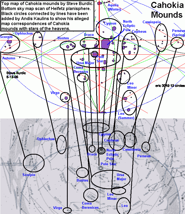
My decipherment of the Cahokia Mounds was made possible through the map recently sent to me by Steve Burdic.

My decipherment shows that the Cahokia Mounds were intended as hermetic representations of the stars of the heavens, including stars from the following modern constellations: those marking the four seasons in the heaven of stars - Aquila (Winter), Scorpio (Autumn) Perseus (Spring) and Leo (Summer).

In addition, Cahokia shows the Pole Star position as well as the position of the North Ecliptic Pole.

Lastly, stars of Ursa Major, Draco, Cepheus, Cassiopeia, Cygnus, Ophiuchus, Bootes, Virgo, Coma Berenices, and Leo Minor are shown.

There may be solar lines here, but that is not my interest at the moment. The major "architectural" features of Cahokia are intended to represent the starry constellations at night.

The correspondences are not always perfect, but the relationship is clear when one views the whole.

The Ursa Major equivalence, e.g. is very well represented. Cepheus and Cassiopeia are both excellently reproduced. Scorpio on the other hand is missing one star at the head, the left one - although this was the first group of stars identified nevertheless due to Antares. Some of the other alleged star positions show too few stars to be certain. Nevertheless, that the mounds represent the stellar heavens is clear, and the principle used is the same as we previously have found throughout the world, also e.g. at Tikal
(see http://www.megaliths.net/mesoamerica.htm).

Using the positions of the stars as obtained, the original plan of Cahokia must be substantially older than currently dated by the scholars - or - their builders relied on long outdated stellar parameters.

Some other sites of interest in this regard are:

Cahokia Mounds Topography - Maps of Cahokia - http://www.museum.state.il.us/vrmuseum/jshape/cahokia2.html

Cahokia Site Map and Virtual Tour - http://www.cahokiamounds.com/virtual_tour.html

Illinois Historic Preservation Agency - http://www.illinoishistory.gov/hs/cahokia_mounds.htm

Archaeological Sites - Cahokia - http://www.mnsu.edu/emuseum/archaeology/sites/northamerica/cahokia.html

Cahokia Mound 72 - http://lithiccastinglab.com/gallery-pages/2001augustmound72excavation1.htm

National Park Service - Cahokia - http://www.cr.nps.gov/worldheritage/cahokia.htm

Mississippian Civilization - http://www.hp.uab.edu/image_archive/up/upi.html

Mississippi Artifacts - http://www.mississippian-artifacts.com/

Gottschall Site - http://www.tcinternet.net/users/cbailey/Gottsiteoverview.html

Indian Mounds of Mississippi - http://www.cr.nps.gov/nr/travel/mounds/

FAMSI - http://www.famsi.org/

Chinese Neolithic Stone Carving of Big Dipper (Ursa Major) Discovered

The Xinhua News Agency reported on August 16, 2006 that a Neolithic stone carving of the stellar constellation of the "Big Dipper" (Ursa Major) has been discovered in China on Baimiaozi Mountain near Chifeng City in China's Inner Mongolia Autonomous Region. They write as follows:

"Neolithic Stone Carving of Big Dipper Discovered
2006-08-17 11:16:01 Xinhua News Agency

13548226_2006081711161687805300.jpg


A neolithic stone carving of the Big Dipper star formation has been found on Baimiaozi Mountain near Chifeng City in northwest China's Inner Mongolia Autonomous Region, according to experts.

The stone carving was discovered by Wu Jiacai, a 50-year-old researcher in literature and history with Wongniute Banner of Inner Mongolia.

Wu found a large yam-shaped stone, 310 centimeters long, onto which 19 stars had been carved. The representation of the Big Dipper is on the north face of the stone.

The stars are represented by indentations in the stone. The biggest indentation is 6 centimeters in diameter and 5 centimeters deep, said Wu.

"The stone was carved by neolithic dwellers," said Gai Shanlin, researcher with the Inner Mongolia Institute of Cultural Relics and Archaeology (IMICRA) and an expert in stone carving.

The carving style proves this, said Gai. Astronomers' conjectures about the shape of the Big Dipper some ten thousand years ago also match the carving.
  
13548226_2006081711161727372600.jpg


"Finding a stone carving in China‘s desert hinterland is a rare occurrence," said Tala, director of IMICRA, who said it might help prove how ancient celestial bodies evolved.

Apart from the Big Dipper, Wu also found some "unexplained images" on the stone. He thinks they may depict ancient gods, such as the god of the sun and the god of horses. Further study would be needed to determine when the pictures were painted.

Many neolithic jade articles from the Hongshan Culture -- such as a dragon with a pig's mouth and a cloud-shaped pendant -- have already been unearthed around Baimiaozi Mountain.

The Hongshan Culture was an aboriginal culture that existed in northern China about 6000 years ago.

Tala believes the discovery will contribute to knowledge about the origin and spread of Hongshan Culture.

(Xinhua News Agency August 16, 2006)"

This discovery fits in with the ancient hermetic system of land survey by astronomy discovered by Andis Kaulins in China (see Stars Stones and Scholars), according to which the Great Wall of China marks the Milky Way as the Dragon of Heaven and where e.g. Yumen marks Gemini at the West end of the Great Wall and Shanhaikuan and this region of China mark the Head of the Azure Dragon (Tang Shay) in the East.

Baimiaozi Mountain near Chifeng City in China's Inner Mongolia Autonomous Region is located near the area where the eastern part of the Great Wall of China ends and many other ancient artefacts have been found in this region.

Most Popular Posts of All Time

Sky Earth Native America


Sky Earth Native America 1:
American Indian Rock Art Petroglyphs Pictographs
Cave Paintings Earthworks & Mounds as Land Survey & Astronomy
,
Volume 1, Edition 2, 266 pages, by Andis Kaulins.

  • Sky Earth Native America 2:
    American Indian Rock Art Petroglyphs Pictographs
    Cave Paintings Earthworks & Mounds as Land Survey & Astronomy
    ,
    Volume 2, Edition 2, 262 pages, by Andis Kaulins.

  • Both volumes have the same cover except for the labels "Volume 1" viz. "Volume 2".
    The image on the cover was created using public domain space photos of Earth from NASA.

    -----

    Both book volumes contain the following basic book description:
    "Alice Cunningham Fletcher observed in her 1902 publication in the American Anthropologist
    that there is ample evidence that some ancient cultures in Native America, e.g. the Pawnee in Nebraska,
    geographically located their villages according to patterns seen in stars of the heavens.
    See Alice C. Fletcher, Star Cult Among the Pawnee--A Preliminary Report,
    American Anthropologist, 4, 730-736, 1902.
    Ralph N. Buckstaff wrote:
    "These Indians recognized the constellations as we do, also the important stars,
    drawing them according to their magnitude.
    The groups were placed with a great deal of thought and care and show long study.
    ... They were keen observers....
    The Pawnee Indians must have had a knowledge of astronomy comparable to that of the early white men."
    See Ralph N. Buckstaff, Stars and Constellations of a Pawnee Sky Map,
    American Anthropologist, Vol. 29, Nr. 2, April-June 1927, pp. 279-285, 1927.
    In our book, we take these observations one level further
    and show that megalithic sites and petroglyphic rock carving and pictographic rock art in Native America,
    together with mounds and earthworks, were made to represent territorial geographic landmarks
    placed according to the stars of the sky using the ready map of the starry sky
    in the hermetic tradition, "as above, so below".
    That mirror image of the heavens on terrestrial land is the "Sky Earth" of Native America,
    whose "rock stars" are the real stars of the heavens, "immortalized" by rock art petroglyphs, pictographs,
    cave paintings, earthworks and mounds of various kinds (stone, earth, shells) on our Earth.
    These landmarks were placed systematically in North America, Central America (Meso-America) and South America
    and can to a large degree be reconstructed as the Sky Earth of Native America."


    Our Blogs and Websites

    • 99 is not 100 • Aabecis • AK Photo Blog • Ancient Egypt Weblog • Ancient World Blog • AndisKaulins.com • Andis Kaulins Blog • Archaeology Travel Photos (Flickr) • Archaeology Websearch • Archaeo Pundit • Arts Pundit • Astrology and Birth • Baltic Coachman • Biotechnology Pundit • Book Pundit • Chronology of the Ancient World • Easter Island Script • Echolat • edu.edu • Einstein’s Voice • Etruscan Bronze Liver of Piacenza • EU Pundit • Gadget Pundit • Garden Pundit • Golf Pundit • Gourmet Pundit • Hand Proof • House Pundit • Human Migrations • Idea Pundit • Illyrian Language • Indus Valley Script • Infinity One : The Secret of the First Disk (the game) • Isandis (blogspot) • Journal Pundit • Kaulins Genealogy Blog • Kaulinsium • Latvian Blog • LawPundit.com • LawPundit (blog I) • Law Pundit (blog II) • LexiLine.com • Lexiline Journal • LexiLine (ProBoards) • Library Pundit • Lingwhizt • Literary Pundit • Magnifichess • Make it Music • Maps and Cartography • Megalithic World • Megaliths • Megaliths.net • Minoan Culture • Mutatis Mutandis • Nanotech Pundit • Nostratic Languages • Phaistos Disc • Pharaonic Hieroglyphs • Photo Blog of the World • Prehistoric Art Pundit • Private Wealth Blog • PunditMania • Quanticalian • Quick to Travel • Quill Pundit • Road Pundit • Sport Pundit • Star Pundit • • Stars Stones and Scholars (blog) • Stars Stones and Scholars (book) • Stonehenge Pundit • The Enchanted Glass • UbiquitousPundit • WatchPundit • Wine Pundit • Word Pundit •