Many ancient cave paintings were recently discovered (2013) in Tamaulipas, Burgos municipality, Mexico, as reported at BBC News in Cave paintings in Mexico: Carvings uncovered in Burgos:
We also considered the much earlier date of 5000 B.C. if one put the Vernal Equinox at the boat rudder below Auriga and above Orion, and indeed we did find a similar "Sun Line" shadow mark at page 20 in Todd W. Bostwick, Ph.D., Archaeoastronomy of the Southwest, Arizona Archaeological Society, 2007.
However, such an early date appeared too far back for us, but we did note the early dates referred to by K. Krist Hirst at archaeology.about.com in Ocampo Caves (Tamaulipas, Mexico): Evidence for Early Domestication of Crops.
In making our graphic image illustrations, we considered photographs by the Instituto Nacional de Antropología e Historia (INAH), photos found at the Los Angeles Review of Books in Gustavo A. Ramirez on the Rock Art of Burgos, Tamaulipas, Mexico and photos at La Gran Época, Anastasia Gubin, México: descubren 5000 pinturas rupestres en cuevas de Tamaulipas: La mayoría tiene un grado de conservación impresionante y representa sus viviendas, sus costumbres y formas de vida.
Our decipherment below shows a wall section of cave painting figures found at the Cave Painting of the Cave of the Indian, "Cueva del Indeo".
As seen there, some familiar star clusters (today constellations) are clearly marked, as is the Milky Way (the area we have marked in light blue).
The hour-glass figure of Orion is unmistakable, and the rest follow logically after that. Cancer, Gemini, and Auriga (unusual as a boat for these stars) are clearly marked above the Milky Way, Perseus in turn is marked in the Milky Way, and Canis Major, Orion and Taurus (the latter found in an unusual representation as two halves) together with the Hyades are marked below the Milky Way.
The locational mesh of star clusters and Milky Way (properly placed above, in or below that Milky Way) serves as very strong probative evidence for the correctness of our identification of the prominent star groups.
The "underworld" of the ocean below the Milky Way then shows Canis Major (with Sirius), Puppis (as a squid?), Carina as an electric (?) eel (with "shock" symbols ?, and with the major star Canopus as the eel's eye), and Columba as a turtle. Stars between Orion and Canis Major are seen as a fence.


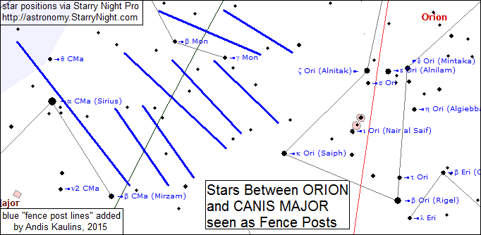
Viewing these stars as "fence posts" is otherwise unknown to us in ancient astronomy, but one can see from the above image -- where we have drawn in the blue fence post lines -- that such a view fits the stars, and it indeed thus adds further probative value to the decipherment of the cave painting as presented above.
We know from our immediately preceding posting that the mounds of Poverty Point in Louisiana, USA, represent stars of the heavens that form the shape of a flying bird, which we call the "Thunderbird", found in close proximity and to the right of the famous star cluster of the Pleiades. These mounds by our decipherment marked the Vernal Equinox in ca. 1675 B.C.
We therefore sought evidence that Equinoxes and/or Solstices were similarly and systematically marked by stars in other previous eras in Native America.
Looking at the stars of Perseus and the Pleiades, to the left of them we find the stars of Taurus and lower and to the left we find the stars of Orion.
Looking at a map of North America, we saw that if it was marked consistently in the same system as Poverty Point, then we would surely have to cross the Gulf of Mexico to look for Native American sites that may have marked the stars of Taurus and/or Orion. Tamaulipas, Burgos Municipality, fit the bill, marking ca. 2300 B.C. when the Celestial Equator split Taurus as apparently marked in the cave painting and when the Vernal Equinox was left of the Pleiades in Taurus.
Stars along the Milky Way from Canis Major (and some stars below and to the left of that) to Perseus are marked on the cave painting of the "Cave of the Indian" -- "Cueva del Indeo", although the chronological dating of the figures is still uncertain, with the options of ca. 2300 B.C. or ca. 5000 B.C. both possible, with the latter, however, very unlikely in our opinion. It will be interesting to see what the radiocarbon data ultimately tell us.
THIS POSTING IS Posting Number 14 of
The Great Mound, Petroglyph and Painted Rock Art Journey of Native America
Cave Painting in Cave of the Indian in Tamaulipas Burgos Municipality Mexico Marks Taurus and Other Stars ca. 2300 B.C.
"Archaeologists in Mexico have found 4,926 well-preserved cave paintings in the north-eastern region of Burgos ... in 11 different sites."As written by Meredith Bennett-Smith at the Huffington Post in Nearly 5,000 Ancient Cave Paintings Found In Mexico:
"This photo released by the National Institute of History and Anthropology (INAH) in Mexico, shows cave paintings found in the San Carlos mountain range in the Burgos municipality of the Tamaulipas State, Mexico. Archaeologist Martha García Sánchez said the paintings were made by at least three groups of hunter-gatherers and show hunting, fishing, housing, animals as well as religious and astronomical symbols. According to archaeologists the paintings have not been dated because they have yet to collect samples of the pigments used in the images."Read the article to see a number of photos of the main cave paintings, one of which we decipher below as marking stars, perhaps ca. 2300 B.C. when the Celestial Equator split Taurus in two, with the cave painting showing such an unusual splitting of stars in this region.
We also considered the much earlier date of 5000 B.C. if one put the Vernal Equinox at the boat rudder below Auriga and above Orion, and indeed we did find a similar "Sun Line" shadow mark at page 20 in Todd W. Bostwick, Ph.D., Archaeoastronomy of the Southwest, Arizona Archaeological Society, 2007.
However, such an early date appeared too far back for us, but we did note the early dates referred to by K. Krist Hirst at archaeology.about.com in Ocampo Caves (Tamaulipas, Mexico): Evidence for Early Domestication of Crops.
In making our graphic image illustrations, we considered photographs by the Instituto Nacional de Antropología e Historia (INAH), photos found at the Los Angeles Review of Books in Gustavo A. Ramirez on the Rock Art of Burgos, Tamaulipas, Mexico and photos at La Gran Época, Anastasia Gubin, México: descubren 5000 pinturas rupestres en cuevas de Tamaulipas: La mayoría tiene un grado de conservación impresionante y representa sus viviendas, sus costumbres y formas de vida.
Our decipherment below shows a wall section of cave painting figures found at the Cave Painting of the Cave of the Indian, "Cueva del Indeo".
As seen there, some familiar star clusters (today constellations) are clearly marked, as is the Milky Way (the area we have marked in light blue).
The hour-glass figure of Orion is unmistakable, and the rest follow logically after that. Cancer, Gemini, and Auriga (unusual as a boat for these stars) are clearly marked above the Milky Way, Perseus in turn is marked in the Milky Way, and Canis Major, Orion and Taurus (the latter found in an unusual representation as two halves) together with the Hyades are marked below the Milky Way.
The locational mesh of star clusters and Milky Way (properly placed above, in or below that Milky Way) serves as very strong probative evidence for the correctness of our identification of the prominent star groups.
The "underworld" of the ocean below the Milky Way then shows Canis Major (with Sirius), Puppis (as a squid?), Carina as an electric (?) eel (with "shock" symbols ?, and with the major star Canopus as the eel's eye), and Columba as a turtle. Stars between Orion and Canis Major are seen as a fence.
Tamaulipas, Burgos Municipality, Mexico
The Cave Painting in the Cave of the Indian, "Cueva del Indeo"
Marks Orion and Neighboring Stars
With Taurus Split by the Celestial Equator ca. 2300 B.C.
With Taurus Split by the Celestial Equator ca. 2300 B.C.
Stars from Sirius to Perseus along the Milky Way Are Included
The Corresponding Stars are Marked in Blue in the Image Below
The stars between Canis Major and Orion seen as fence posts
Viewing these stars as "fence posts" is otherwise unknown to us in ancient astronomy, but one can see from the above image -- where we have drawn in the blue fence post lines -- that such a view fits the stars, and it indeed thus adds further probative value to the decipherment of the cave painting as presented above.
We know from our immediately preceding posting that the mounds of Poverty Point in Louisiana, USA, represent stars of the heavens that form the shape of a flying bird, which we call the "Thunderbird", found in close proximity and to the right of the famous star cluster of the Pleiades. These mounds by our decipherment marked the Vernal Equinox in ca. 1675 B.C.
We therefore sought evidence that Equinoxes and/or Solstices were similarly and systematically marked by stars in other previous eras in Native America.
Looking at the stars of Perseus and the Pleiades, to the left of them we find the stars of Taurus and lower and to the left we find the stars of Orion.
Looking at a map of North America, we saw that if it was marked consistently in the same system as Poverty Point, then we would surely have to cross the Gulf of Mexico to look for Native American sites that may have marked the stars of Taurus and/or Orion. Tamaulipas, Burgos Municipality, fit the bill, marking ca. 2300 B.C. when the Celestial Equator split Taurus as apparently marked in the cave painting and when the Vernal Equinox was left of the Pleiades in Taurus.
Stars along the Milky Way from Canis Major (and some stars below and to the left of that) to Perseus are marked on the cave painting of the "Cave of the Indian" -- "Cueva del Indeo", although the chronological dating of the figures is still uncertain, with the options of ca. 2300 B.C. or ca. 5000 B.C. both possible, with the latter, however, very unlikely in our opinion. It will be interesting to see what the radiocarbon data ultimately tell us.
THIS POSTING IS Posting Number 14 of
The Great Mound, Petroglyph and Painted Rock Art Journey of Native America
Cave Painting in Cave of the Indian in Tamaulipas Burgos Municipality Mexico Marks Taurus and Other Stars ca. 2300 B.C.


 -----

